healthyng

Archives 2023

The best islands in Central America are a taste of tropical paradise

You have to pity historic seafarers – with so many paradise islands to choose from in Central America, it must have been a daily challenge deciding where to weigh anchor. Stunning specks of green jungle and blond sand dot the coastline of the isthmus, all different from one another, and some quite unusual.

To set the scene, one island – more than 300 miles off the coast of Costa Rica – is said to have inspired Robert Louis Stevenson’s Treasure Island. And real-life pirates once menaced this stretch of ocean, setting up secret bases on islands such as Roatan 0ff the coast of Honduras.

Many of the best-known isles are strung out along the Caribbean Coast, but there are also islands off the Pacific Coast, and more dotted around Central America’s volcanic lakes. Some are composed of limestone and sand, while others were thrown up by volcanoes or spawned by coral reefs, and all offer a uniquely Central American taste of the tropics.

Regardless of which island you choose, pack your sunscreen and a sense of adventure. Here’s our pick of the best islands in Central America.

Bocas del Toro, Panama, is the perfect tropical getaway

Best for a Caribbean vibe

When people envision a dream Caribbean getaway, clear turquoise waters, swaying palm trees and brightly colored weatherboard houses are almost obligatory, and you’ll find all of this and more at Bocas del Toro. This lively archipelago off the northwestern shore of Panama consists of a sprinkling of sun-sizzled islands, all with different vibes and offerings, along with hundreds of tiny uninhabited islets.

You can show up by plane from Panama City or David, by ferry boat from Almirante, or from Puerto Viejo and Cahuita in Costa Rica. Most visitors stay on Isla Colón, the most popular and populated island, but you can also park up on quieter, forested Isla Carenero or Isla Bastimentos – the largest and most chilled out of the islands.

Short trips by water taxi connect these and other main islands, and popular ways to pass the time include boat trips to spot dolphins and mangrove birdlife, inland hikes, surfing, coastal kayaking and snorkeling, and tours of cacao farms, plus plenty of lazing on the sand.

For island life with more action, head to Ambergris Caye, Belize

Best for reefs and nightlife

A sizable crowd of North American escapees have set up base in the seaside condos on pretty Ambergris Caye, the largest island on the Caribbean coast of Belize. Who can blame them? From beaches and diving on the largest barrier reef in the Americas to buzzing nightlife, Ambergris Caye has everything.

For starters, you’ve got the sugar-sand beaches and mangrove-lined lagoons, and you can add in glitzy resorts and the lively downtown hub of San Pedro, frequented by convivial locals and sun-dazed tourists zipping around in golf carts. It’s the perfect mix for travelers who like a bit of comfort and action with their island paradise.

And Ambergris offers seemingly infinite opportunities for recreation – beachside water sports, waterslides and ziplines, secret beaches, and of course, spectacular diving and snorkeling on the barrier reef system offshore. Spend a day here and you’ll quickly understand why this is Belize’s top tourist draw. Getting to Ambergris is easy by boat from Belize City, Corozal or Chetumal in Mexico, or by plane from airstrips all over Belize, but leaving can feel much harder!

Boats at Secret Beach on Ambergris Caye, Belize
Ambergris Caye is the full tropical island experience © Felipe Santiago / 500px / Getty Images

Isla de Ometepe, Nicaragua, is ripe for adventure

Best for adventure activities

Formed by two conjoined volcanoes rising from the middle of Lake Nicaragua, the island of Ometepe is Central America’s premier stop for backpackers seeking outdoor adventure. Thrill-seekers arrive by ferry from the port town of St Jorge and dive straight in, renting scooters, riding horses to jungle waterfalls, kayaking on the Istián River or summiting the 1394m (4573ft) Maderas Volcano.

For less intrepid travelers, there’s great swimming on the beaches near the Ecological Reserve Charco Verde – a pretty lagoon sold rather short by its prosaic name which means ‘green puddle.’ Finding petroglyphs is another rewarding activity; nearly 1700 carvings adorn rocks across the island. We also recommend taking a tour of Finca Magdalena, a large organic coffee farm that also doubles as a hostel and restaurant.

Honduras’ blissful Bay Islands are an underwater playground

Best for cheap diving

Formed by an underwater mountain range, these long, narrow wisps of land off the northern coast of Honduras offer some of Central America’s best underwater adventures. The largest and best-known island, Roatán, was once a notorious pirate hangout, but these days it caters to rather more mid-range travelers, drawn here by chic resorts and paradisiacal white sand beaches. Neighboring Guanaja is mostly visited by divers on all-inclusive packages.

To the west, tiny Utila is the budget option, with abundant cheap accommodation, a fun traveler scene, and some of the most affordable scuba certification courses in the world (with open-water certification going for around US$285). Additional draws include year-round whale shark sightings and backpacker parties that roam around the island’s bars.

Fast ferries run to the islands from La Ceiba on the mainland, but some visitors opt to fly, with direct shuttle flights to Roatán from the US as well as from La Ceiba and other cities in Honduras.

Taucher ueber Korallenriff, Utila, Karibik, Honduras | Diver over Coral Reef, Utila, Caribbean Sea, Honduras
128930052
Aquatic,  Bay Island,  Caribbean Sea,  Coral,  Coralreef,  Coralreefs,  Dive,  Diver over Coral Reef,  Diving,  Diving,  Hard Coral,  Hardcoral,  Honduras,  Islas de Bahia,  Marine Wildlife,  Nature,  Ocean,  Ocean,  Reef,  Reefs,  Sealife,  Soft Corals,  Softcoral,  Underwater,  Underwaterphoto,  Utila,  adventure,  adventurous,  buddie,  buddy,  coral reef,  corals,  diver,  diving,  hobby,  holiday,  holidays,  recreational,  sport,  sportdiver,  sportdiving,  sporting,  sports,  sporty,  swim,  swimming,  tourism,  tourist,  tourists,  travel,  travelling,  underwaterimage,  underwaterphotography,  underwaterpicture,  underwaterpictures,  underwaterworld,  vacation,  water,  watersport, scuba
Utila is one of the cheapest places in the world to learn to dive © Joe Dovala / Getty Images

Archipiélago de San Blas, Panama is totally off-grid

Best for escaping the world

An adventurous stopover for those traveling between Panama and Colombia, the Archipiélago de San Blas – or Guna Yala, as locals call it – is a 365-island stunner self-governed by the Guna community, the first indigenous group in Latin America to secure political autonomy. There’s been almost no development here save for palm-thatched villages and livestock enclosures, and the tourist experience is delightfully rustic. There are no resorts, just camping grounds and cabañas (beach huts), and no internet access, which is exactly the point.

Most travelers arrive on sailboats from the mainland port of Gardi (Cartí) and kick back beside pristine, powdery beaches. Days are spent frolicking in the crystal-clear surf or gliding over coral reefs with masks pointed down at the undersea ecosystem. A stay here is also a chance to immerse yourself in Guna culture, which is famed across the region for its traditional dancing and artful crafts.

The tiny islands of Las Isletas, Nicaragua, are great for day-trippers

Best for freshwater island-hopping

About 20,000 years ago, Nicaragua’s Mombacho Volcano violently erupted, launching enormous boulders into nearby Lake Nicaragua. Over time, these became Las Isletas – more than 300 tiny islands supporting abundant vegetation and thriving birdlife, found just a short hop from Nicaragua’s former colonial capital, Granada.

You can stay over on some islands, but day-trippers can cruise around the islets in a panga boat or paddle around by kayak and spy on the opulent vacation homes of some of Nicaragua’s most prosperous families. Most of the islands are only big enough for a single home, restaurant or resort, but one island boasts an 18th-century Spanish fortress. For an utterly tranquil escape, hunker down at the Jicaro Island Lodge for a few days.

Tourists kayaking on Lake Nicaragua
Kayaking is one of the most atmospheric ways to explore Lake Nicaragua © John & Lisa Merrill / Getty Images

Caye Caulker, Belize is the epitome of relaxation

Best for backpacker beach fun

If Ambergris Caye is Belize’s hyperactive and attention-grabbing diva, Caye Caulker is its chilled-out, devil-may-care younger sibling. This slender island is sought out by international backpackers and footloose families who like to spend their vacations relaxing in hammocks beside white powder beaches, and sipping fruity rum-based drinks at beachside reggae bars.

For those who simply must go exploring, there are bikes and golf carts for rent and the impossibly turquoise sea beckons on all sides, with great snorkeling and kayaking and chances to spot manatees in mangrove lagoons. Visitors arrive by ferry boat or plane either from Belize City or from Ambergris Caye.

Corn Islands, Nicaragua

Best for a low-key island escape

Off the Caribbean coast of Nicaragua, these far-flung islands are blissfully devoid of large-scale development. Instead, you’ll find stilted-mounted, multi-colored cabañas, toothsome seafood and idyllic, unspoiled beaches. Lobster catching and tourism are the principal industries, and popular island pursuits include relaxing in hammocks strung between palms and snorkeling in the bathtub warm sea.

The two Corn Islands – Great Corn and Little Corn – are a half-hour boat ride apart and are accessed via plane or ferry from Bluefields, or flights from Managua. Tourists tend to prefer Little Corn as it’s the more charming of the two, with better snorkeling and diving and a bigger selection of restaurants.

Hammocks strung between palm trees on Little Corn island, Nicaragua
There’s a hammock with your name on it on Little Corn island © Philip Lee Harvey / Lonely Planet

Easy going Flores, Guatemala, is the gateway to Mayan wonders

Best for Mayan history

In the southern part of Guatemala’s Lake Petén Itzá, backed by vast swaths of rainforest and accessed by a narrow causeway, Flores is first and foremost a base for exploring Tikal, the most impressive ruined Mayan city in all of Central America. But it’s a lot more than that.

Cobblestone streets, romantic plazas and restaurants and guesthouses with elegant roof terraces define this easygoing town, and it even has its own set of modest Mayan ruins lining the lakeshore. Flores is also a perfect launching point for lake swimming or boating, and a place to take lovely sunset strolls along unsubmerged sections of the promenade that rings the island.

Isla del Coco, Costa Rica is full of tall tales and incredible wildlife

Best for finding the real Treasure Island

About 300 miles southwest of mainland Costa Rica, Parque Nacional Isla del Coco is a far-flung national park and UNESCO World Heritage site with a rich seafaring history. This remote island was reputedly the inspiration for Robert Louis Stevenson’s Treasure Island, and off its shores, hammerhead sharks gather by the hundreds because their food source is constantly replenished by cold, nutrient-rich waters colliding with a submerged mountain range.

Whale sharks and humpbacks often show up for the party, as do divers on liveaboard trips from Puntarenas on the Costa Rican mainland – which are the only way to reach this somewhat inaccessible idyll. Because the island is the only source of freshwater for hundreds of miles, it became an important refuge for whalers and raiding pirates in the 17th century. Treasure is supposedly hidden within the island’s yawning caves, though numerous expeditions have so far failed to unearth anything of significance.

You may also like:
The best Mayan sites in Central America: Pyramids of power
The 14 best beaches in Central America
15 things you absolutely must do in Central America
These 5 long walks will show you the best of San Francisco

The best way to see San Francisco is on foot – hills be damned. Long strolls will let you fully appreciate the city’s nuances, quirks and endless appeal.

We’ve compiled five long walks that will take you into the historic heart of the city and explore some of its most diverse neighborhoods. Even in the center of the city, you can expect encounters with nature while enjoying the fabulous views that are part of the city’s lore. You’ll even get up close and personal with some of the city’s top icons. Whether you have two hours or most of a day, one of these walks will suit you. Along the way, you’ll discover opportunities for good food and drink, as well as shops like none you’ll find elsewhere.

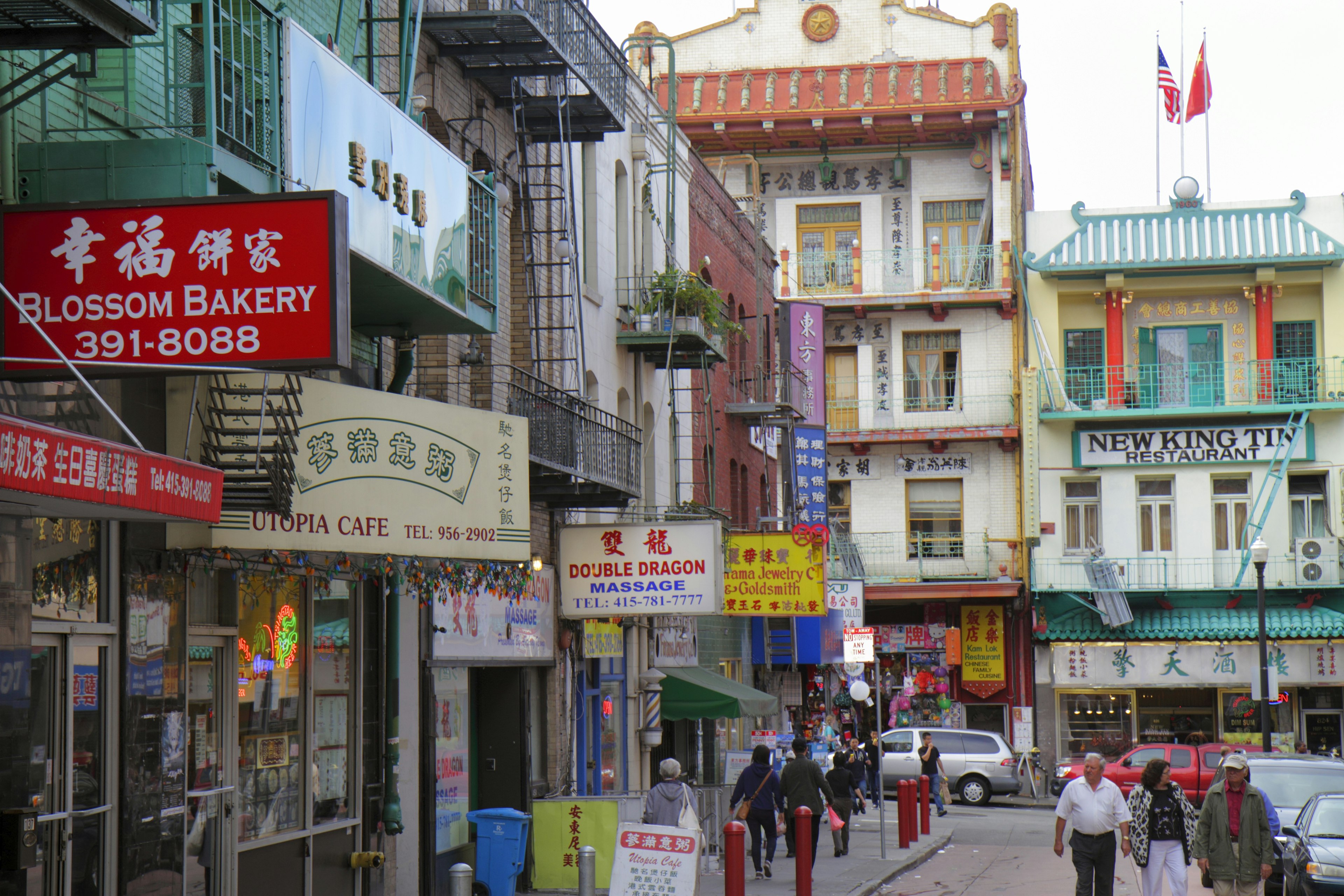
Colorful signs in English and Mandarin adorn the facades of buildings on Washington Street in Chinatown, San Francisco, California, USA
Spend some time poking around the narrow, atmospheric streets of Chinatown. Jeffrey Greenberg/Universal Images Group via Getty Images

1. Chinatown and North Beach

Best for essential San Francisco
1.5 miles one-way, 3 hours, moderate

This itinerary starts in Chinatown at Portsmouth Square, the neighborhood’s unofficial living room. The square is graced by the Goddess of Democracy, a bronze replica of the statue that Tiananmen Square protesters made in 1989.

Stop in at the Chinese Historical Society of America, dedicated to the experiences of Chinese immigrants to the USA during the gold rush, construction of the transcontinental railroad and the decades that followed, with virulent racism a steady backdrop. Meander north on the busy, shop-lined streets, watching for the 41 historic alleyways packed into Chinatown’s 22 blocks. Don’t miss Waverly Place and its historic clinker-brick buildings and flag-festooned temple balconies.

Cut over to Columbus Ave and the heart of San Francisco’s Beat culture at Jack Kerouac Alley. Take note of the words of Chinese poet Li Po embedded in the alley: “In the company of friends, there is never enough wine.” And indeed, in the 1950s, Kerouac, Arthur Miller and other literary icons used to raise a few at the neighboring bar Vesuvio. Nearby is legendary City Lights Books, one of America’s best bookshops.

Continue up Columbus through the heart of North Beach, which still has discernible Italian roots. At lushly planted Washington Square, you’ll spot parrots in the treetops and octogenarians in tai chi tiger stances on the lawn.

Next, head up steep, residential Greenwich St to Coit Tower – and the best views in the city. The exclamation point on San Francisco’s skyline, this stark, white art deco structure is surrounded by a park, from which thrilling vistas open up from the Golden Gate to the Bay Bridge and beyond. Take time to duck into the tower’s lobby, where murals depict city life during the Depression: people lining up at soup kitchens, organizing dockworkers’ unions, partying despite Prohibition and more. These scenes have riled up conservatives since they were first unveiled.

Now, head east and down the Filbert Street Steps. The steep climb leads past hidden cottages along Napier Lane, more sweeping views and more colorful wild-parrot flocks. Continue across the Embarcadero to the waterfront at Pier 23, where you turn left for Fisherman’s Wharf or right for the Ferry Building.

A woman stops to look at the colorful murals in Clarion Alley in the Mission neighborhood, San Francisco, California, USA
The Mission’s countless murals enliven this vibrant neighborhood. Sabrina Dalbesio for Lonely Planet

2. The Mission

Best for seeing San Francisco’s contradictions on display, and for murals
2.75 miles one-way, 3 hours, easy

The Mission is a crossroads of contradictions. At its heart is Mission St, SF’s faded “miracle mile” that’s now occupied by dollar stores and rollicking street life, festooned with colorful murals and filled with buzzy restaurants. West of Mission St, Valencia St has both quirky boutiques and seven-figure condos. Calle 24 (24th St) is SF’s designated Latino Cultural District. A walk through the Mission puts the multitudes that modern San Francisco contains on full display.

Begin at the city’s first building and neighborhood namesake: the adobe Mission Dolores, built by some 5000 conscripted Ohlone and Miwok laborers in the 18th century. (You can see the Miwok memorial hut, dedicated to these anonymous laborers, through the mission fence on Chula Lane.) Hitchcock fans will note a prime filming location from the 1958 classic Vertigo.

Climb to the upper southwestern corner of Dolores Park for panoramic views and prime people-watching. Then walk down 19th St, past Daniel Doherty’s impressionist-inspired 2009 mural A Sunday Afternoon at Dolores Park, which depicts Dolores Park’s regular cast of characters, including frolicking pugs and handlebar-mustached men in matching swim shorts.

On Valencia, pause to pay your respects to bygone celebrities at Dog Eared Books: the front window features hand-drawn obituary cartoons of luminaries. Window-shop down Valencia, then hang a left onto Calle 24, where you’ll pass community centers, churches, bodegas, panaderias (bakeries) and taquerias all swathed in murals. Stop at 24th & York Mini Park, where Aztec serpent-god Quetzalcoatl rears his mighty mosaic head.

Double back along 24th St, cross over and swing down to Balmy Alley, where you may recognize beatified activist Archbishop Romero and surrealist painter Frida Kahlo among the colorful characters illuminating garage doors. Since you’ll have worked up an appetite by now, join the line at La Taqueria for one of SF’s best burritos. Get yours dorado–style, with a crispy surface.

Two people walk by Andy Goldsworthy’s “Woodline” installation in a wooded area of the Presidio, San Francisco, California, USA
In addition to beaches and bridge views, the Presidio offers a taste of nature in the middle of the city. Kali Conlon/Getty Images

 3. Presidio and Crissy Field

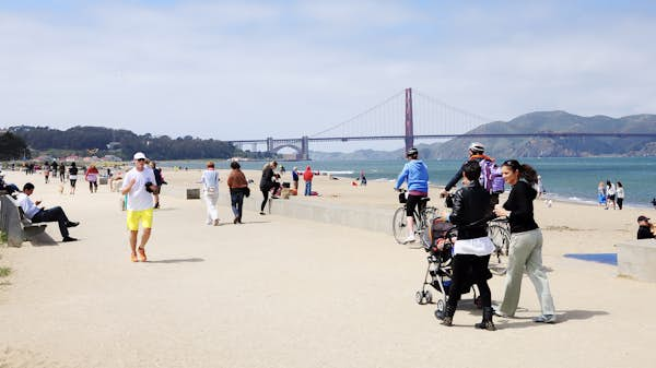
Best for views of the ocean, bay and Golden Gate Bridge
3.5 miles one-way, 4 hours or more, easy

As you explore the Presidio, the vast splotch of green on the map between Baker Beach and Crissy Field, you’ll find parade grounds, historic buildings by the dozen, beautiful natural areas and some fascinating art projects. What started as a Spanish fort built by Ohlone conscripts in 1776 is today a treasure hunt of surprises. It was decommissioned as a military base in 1994 and turned over to the National Park Service (NPS), which has been transforming it into one of the nation’s most exciting urban parks. Download the NPS Presidio app for details on trails and sights.

At mile-long Baker Beach, you can take in the spectacular views of the Golden Gate. Crowds descend on weekends, especially on fog-free days, so arrive early. For nude sunbathing, head to the northern end. Mind the currents and the c-c-cold water.

Hike up along the Batteries to Bluffs Trail, which follows the coast and offers spectacular views from bluffs where huge guns once defended San Francisco. Head inland to Fort Winfield Scott, with its flat parade ground and vintage buildings. Curve east on paths along Lincoln Blvd and enjoy the bay and bridge views.

At the manicured Main Parade Lawn, cafes and museums await. The Presidio Officer’s Club is the site’s oldest building, its gorgeous Spanish-Moorish adobe architecture dating to the 1700s. The free Heritage Gallery shows the history of the Presidio, from Native American days to the present, along with temporary exhibitions.

Cross over the new grasslands covering Hwy 101 and head down to Crissy Field, a military airstrip turned waterfront nature preserve with knockout Golden Gate views. Bird-watchers, walkers, windsurfers, kitesurfers and cyclists flock here. Rent a bike and join the fun, or sit on the beach and watch for the gray whales that sometimes venture into the bay.

Crowds walk by Victorian-style buildings in the Haight-Ashbury neighborhood in San Francisco, California, USA
Before you take in the huge expanse of Golden Gate Park, stroll through the lively streets of Haight-Ashbury. Sergio TB/Shutterstock

4. Haight and Golden Gate Park

Best for hippie culture and a fun-filled park
4.5 miles one-way, 4 hours or more, easy

Begin this long walk in Buena Vista Park, with its panoramic city views, then head west up Haight St and into the neighborhood that defined the Summer of Love in 1967. Hippie flashbacks are a given here, where the fog is fragrant downwind of Haight St’s legal marijuana dispensaries.

Turn right onto Waller St and left uphill past 432 Delmar St, site of the Sid Vicious overdose that broke up the Sex Pistols in 1978. A block over, pay your respects to Jerry Garcia, Bob Weir and Pigpen at the Grateful Dead House. Down the block, 635 Ashbury St is one of many SF addresses associated with Janis Joplin, who had a hard time hanging onto leases in the 1960s.

At the corner of Haight and Ashbury, the clock overhead always reads 4:20 – better known in “Hashbury” as International Bong-Hit Time. Follow your bliss to the drum circle at Hippie Hill in Golden Gate Park, where free spirits have gathered since the ’60s to sway to the beat.

This blissful green space sprawls across 1017 wonderful acres, with a variety of sites that hold something for every interest. Heading west toward the ocean, you can see carnivorous plants gobbling insects at the Conservatory of Flowers, or spot blue butterflies in the rainforest dome at the California Academy of Sciences. Perhaps you’ll choose to get lost in the art galleries of the de Young Museum, or maybe you’ll allot a couple of hours to sipping green tea in the Japanese Tea Garden. Note that cars were banned from John F Kennedy Dr in 2021, which makes walking here even more enjoyable.

Continuing west, there’s the walk to the summit at Strawberry Hill and the namesake large, furry critters grazing at the Buffalo Paddock. The sound of the surf means you’re close to the Pacific and magnificent 4-mile-long Ocean Beach.

A man looks up along a pedestrian path at the side of a road on a large orange-colored suspension bridge
What’s the best way to get an up-close look at the Golden Gate Bridge? By walking across it. Catalina E Ioana / Shutterstock

5. The Golden Gate Bridge and Sausalito

Best for dramatic views and nature
5 miles one-way, 4–6 hours, moderate

One of San Francisco’s best walks takes you immediately out of the city. But what a walk it is.

Your first steps will take you onto the Golden Gate Bridge, which you’ll cross before bending around the bay to the delightful town of Sausalito, and a ferry back to SF. (Confirm the ferry schedule before you set out.) Expect sweeping views of the city and extensive natural beauty that surprises so close to a major metropolis.

The city’s most spectacular icon towers 80 stories above the roiling waters of the Golden Gate, the narrow entrance to San Francisco Bay. Begin your walk at the Golden Gate Bridge Welcome Center at the south end, where you’ll learn how the monumental undertaking was completed in 1937, a mere 4 years after construction began.

Pedestrians will take the eastern sidewalk. Be sure to dress warmly: It’s 1.7 miles across, and you’ll want to take your time for the views, both horizontal and vertical. If you’re lucky, you’ll get to look right down the funnel of a passing ship.

At the north end, follow the curving walkway and road all the way down to Ft Baker and Horseshoe Bay. This former military post, which must have one of the world’s best views, served as a defensive position for much of the 20th century.

Continue on East Rd along the tree-lined coast north into Sausalito, where you can stroll the cute town center and enjoy some of the region’s best seafood in a waterfront cafe like Fish. On a Golden Gate Ferry for the 30-minute ride to the Ferry Building in SF, you’ll go right past Alcatraz.

6 ways to discover NYC’s Roosevelt Island

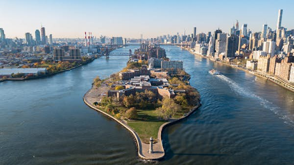
Unfurling like an eel in New York City’s East River, Roosevelt Island is a full 2 miles long yet a mere 800ft across at its widest point.

This long sliver of prime real estate has a fascinating history: for almost 150 years, it was the site of numerous hospitals, prisons, asylums and other grim institutions to which “undesirable” patients and inmates were banished. Over the last half-century, however, a remarkable planned community has taken root, with some 12,000 New Yorkers who live a uniquely low-key version of big-city life now calling the redeveloped island home.

In recent years, further grand projects – including a mighty memorial park and a cutting-edge tech campus – have continued to put space between the island’s troubled history and its lovely present, drawing visitors from all over. And the preferred way to get to the island may be the most exciting part of any excursion here.

Intrigued yet? Here’s how to get to know Roosevelt Island, in six ways.

Hang out (literally) in NYC’s only cable car

Despite its super-central location, Roosevelt Island remained unconnected to the rest of the city for centuries. Today, a road bridge to Queens, a subway stop and a new-ish ferry terminal offer many ways to cross the water – yet none compares to what might be the island’s most famous attraction.

There might be no better ride for the money in New York than the iconic red cable car (or aerial tram) that departs from Midtown Manhattan. Gripping fast-moving steel cables above, the bus-sized cabin quickly makes a vertiginous ascent (almost 250ft!) in a couple of minutes, as it floats with surprising smoothness between a forest of high rises and the tower of the Ed Koch Queensboro Bridge. Before you know it, the East River is beneath you, and the skyline becomes a spectacular panorama as the tram whisks you across the water. The descent comes quickly – hopefully before you’ve had time to recall that harrowing rescue scene from Spider-Man. All for the price of one MetroCard swipe.

Detour: On your way up, you might catch a quick glimpse of a historic stone-fronted structure between the ultra-modern buildings of E 60th St. Dating to the 18th century, the Mount Vernon Hotel was built as a country inn for day-trippers escaping the clamor of the city, whose limits then ended many miles downtown. (Who needs the Hamptons?) The improbably preserved building offers a fascinating glimpse into Manhattan’s bucolic past.

The Roosevelt Island tram and the Queensboro Bridge
Getting to Roosevelt Island via the aerial tramway is half the fun. Getty Images

Consider the island’s grim history at the ruins of the Smallpox Hospital

Native Americans first arrived on Roosevelt Island some 12,000 years ago, before Dutch colonists “purchased” the land in the 17th century and cleared it for farmland. The Blackwell later family settled the island over four generations before selling the whole lot – then known as Blackwell’s Island – to the government in 1828. (The deal was negotiated on the porch of Blackwell House, a 1796 mansion that still stands.)

Over the following century, New York City authorities turned the island into a complex of institutions designed to house – or, really, to get rid of – some of the city’s most vulnerable populations. A notorious prison, insane asylum, workhouse and hospitals for patients with smallpox, typhus and other infectious diseases soon gave Blackwell’s Island a well-deserved reputation for Dickensian squalor.

Happily, these institutions are long gone, with parks, playgrounds and other public spaces today occupying their former sites. Yet one physical trace of this past remains: the ruins of the Smallpox Hospital, to the island’s south. Now covered in ivy and hollowed out by the elements, this castle-like pile (now fenced off for safety) once housed patients who suffered greatly – or worse. As you take in the decaying structure’s eerie appeal, spare a thought for those who visited Roosevelt Island through no choice of their own.

Local tip: A row of cherry trees grows on the waterside pathway that leads from the tram to the island’s southern tip. Come April, they put on quite the show – and shots of these glorious white and pink blossoms against the backdrop of Manhattan will activate major FOMO among your followers.

People outside the fence at the ruin of Smallpox Hospital, Roosevelt Island, New York City, New York, USA
Today an atmospheric ivy-covered ruin, the Smallpox Hospital once housed patients with incurable diseases. Education Images/Universal Images Group via Getty Images

Feel the calming grandeur of Franklin D Roosevelt Four Freedoms Park

The last project of master architect Louis Kahn, this monument to the legacy of President Franklin D Roosevelt (the island’s namesake) was left unrealized until 38 years after Kahn’s death. The stark yet uplifting result was well worth the wait. After ascending a grand set of marble steps just beyond the Smallpox Hospital, visitors traverse a lawn, flanked with elegantly planted trees, that tapers to a bust of FDR, the text of his famous “Four Freedoms” speech engraved on marble slabs that flank the sculpture. On the other side of the panels lies the pièce de résistance: “The Room,” a wide, water-level terrace that turns the very southern tip of the island, with New York’s skyline unfolding all around, into an extraordinary space for quiet reflection.

Local tip: From here, you’ll enjoy perhaps the best view in town of the modernist United Nations complex. The formation of this multilateral institution – and the establishment of its seat in New York – is one of FDR’s many important legacies.

People walk by a bust of FDR toward the East River beyond at Franklin D Roosevelt Four Freedoms Park, on Roosevelt Island, New York City
Four Freedoms Park is both austere and moving. Paolo Bona/Shutterstock

Meet the start-up founders of tomorrow at the Cornell Tech campus

Put on a hoodie and sport sandals with white socks, and you might just pass for a student at Cornell Tech, a cutting-edge campus that’s been a work in progress (from scratch) over the last 15 years – with much more to come. Within these ultra-high-tech buildings, entrepreneurs and graduate students studying computer science, design and business engage in hands-on learning, exchange ideas and launch new companies. (Chances are at least one of them will achieve a trillion-dollar market cap someday.) While the university buildings are off-limits to visitors, the appealingly landscaped grounds feature plenty of lawns and seating areas for the use of laptop-toting students and interlopers alike. Take an alfresco break here for a taste of campus life you’ll find only in New York.

Local tip: After a stressful day in class (even if you’re just playing pretend), nothing lifts the spirits by lifting a glass at the Panorama Room, an 18th-floor bar atop the Graduate, a hotel on the campus. Through floor-to-ceiling windows, you’ll enjoy some of the best views of the city around (and there’s stiff competition).

People walk path through the high-tech university buildings of the Cornell Tech campus, with a view of the Queensboro Bridge in the distance, Roosevelt Island, New York City
Leafy paths wind between high-tech buildings on the Cornell Tech campus on Roosevelt Island. Brian Healy for Lonely Planet

Cycle the island’s perimeter to get a sense of New York City’s mighty infrastructure

The presence of very few cars on Roosevelt Island makes it a cyclist’s paradise, and a bikeable path encircles the island’s entire perimeter. Fresh air, river views and minimal traffic all make for prime pedaling – yet a bike tour of the island provides something even more special: a visual X-ray of the mighty systems that keep New York City going.

Start at the tram station by looking up at the underside of the Queensboro Bridge, with a lattice of steel beams that supports the weight of more than 150,000 crossing vehicles each day. Its four towers topped with decorative spires, this sturdily braced 1909 span is New York City infrastructure at its most Gotham City–esque. Pedaling up the island’s west side, take note of the half-exposed lanes of FDR Dr just across the water, which whisk traffic along the edge of the East River, and underneath the Manhattan apartment buildings, hospitals and parks that are dramatically cantilevered above. With its giant smokestack, the massive power station at E 74th St from 1902 is a beaux-arts marvel. A complementary hulk lies across from the island’s east side: the waterfront, 2480-megawatt Ravenswood Generating Station in Queens, which powers Times Square marquees, Wall Street trading desks, Fashion Week spotlights and everything else that makes the city hum. At the north end of the island, a 50ft-tall lighthouse dates from 1872. Made from locally quarried gneiss (and allegedly built by inmates incarcerated on the island), the beacon is a reminder of the fierce currents that still bedevil ships in these waters.

Local tip: Bring your bike on the F train; the island’s deep station here has elevators serving both platforms. If you’re more ambitious, a protected bike line runs parallel to the East River along Queens’ Vernon Blvd, connecting to the Roosevelt Island Bridge.

Two cyclists pedal along a path on the west side of Roosevelt Island, looking across the East River to the towers of Manhattan, New York City
A bike tour of Roosevelt Island’s perimeter gives you an unexpected perspective on mighty Manhattan, just across the river. Leonard Zhukovsky/Shutterstock

Savor the quiet

A 1969 master plan for Roosevelt Island’s redevelopment called for a mix of apartment towers and green spaces free of cars, a vision that came to pass in the decades that followed. And the residential core of the island is today a neighborhood unlike any other in New York.

While the centrally planned apartment blocks that radiate off Main St aren’t architectural marvels, the plan’s harmonious whole – which includes connecting footpaths and ample greenery – is far more gracious than the sum of its parts. What’s most remarkable is the sheer quiet of it all – the sounds of children playing or joggers huffing interrupted only rarely by a passing car or bus. You won’t be able to catch a cab here. But then again, you won’t need to.

An empty walking path along the East River with white flowering cherry blossom trees and benches during spring on Roosevelt Island of New York City
Roosevelt Island’s ample green spaces, miles of waterfront walkways and lack of cars deliver that rarest of qualities in New York City: quiet. Getty Images
The 10 best things to do in Ecuador

Outdoor adventures, incredible landscapes and diversity-driven culture place Ecuador high on any travel bucket list. Spanning altitude-high Andean cities, sun-kissed beaches and wildlife havens, the South American nation offers some truly epic experiences.

Upon arriving in Ecuador, travelers of all kinds will find themselves enticed by the wide range of options and activities available. Want to hike to the highest point on Earth, swim in the Galápagos Islands and taste one of the finest cacao varieties in the world? That’s all possible in Ecuador.

Buckle up because you’re in for a ride. From exploring the Avenue of Volcanoes to strolling through UNESCO World Heritage Sites, these are the best things to do in Ecuador.

Turtles below the water in the Galapagos Islands
The Galápagos Islands are a true natural wonder © Sebastian Modak / Lonely Planet

1. Enjoy the beauty of the Galápagos Islands

Embark on a journey to the Galápagos Archipelago to explore one of the best-preserved natural sanctuaries on the planet. Hop between islands to see the region’s famous wildlife at places such as the Charles Darwin Station, Tortuga Bay, Lavva Tunnels and Tintoreras Islet. Among the long list of species inhabiting the archipelago — some of which exclusively live in the islands — are giant tortoises, blue footed boobies, iguanas and the only penguins to live by the equatorial line.

Hike along trails untarnished by human activity and enjoy the breathtaking views. For an unforgettable next-level experience, venture on guided scuba diving or snorkeling excursions — encounters with sea lions, rare fish and turtles are guaranteed.

Planning tip: While many sports rentals and tourism agencies offer courses and provide equipment for underwater sports, it is always recommended to bring your own wet suit as rental availability could be limited by size and demand.

2. Visit the Quilotoa Loop

Whether you opt for a full-fledged. multi-day trekking experience or you arrive by car from Quito, stopping by the Quilotoa Loop is non-negotiable.

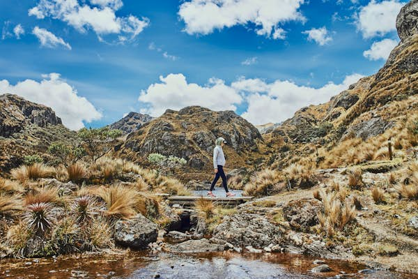
Located about 179km south of Quito, the Quilotoa Loop is a popular hiking destination that sits about 3,910m above sea level at its highest point. With emerald-green waters and a stunning view of the Andean mountain range, this crater lake in the Andean Highlands is either the perfect destination for a hiking trip or an Instagrammable stop-off as you explore the Andean range.

Planning tip: Buses and transportation for day tours can take you straight to the crater, and they’re bookable in nearby Latacunga. Catch a ride up and trek your way back to town, wrapping up your trip with a massive plate of chucgchucaras, Cotopaxi’s star dish.

3. Support community-based tourism in La Amazonía

Communities across Ecuador have crafted sustainable economy initiatives and projects to promote community-based tourism. In the Amazon region, a network of hotels, reserves and guided tours are available thanks to villagers and Indigenous people.

Explore the depths of the Amazon rainforest, learn about the lifestyle and traditions of Indigenous communities and marvel at the extraordinary wildlife at places such as the Sinchi Warmi community center in Puerto Misahuallí or Sani Lodge at the Yasuní National Park.

Known as Ecuador’s gateway to the Amazon, Puerto Misahuallí offers canoe sailing trips down Río Napo, guided tours to the rainforest and animal-watching experiences (spotting Capuchin monkeys at plazas will be free though). At Sinchi Warmi, the women of the Kichwa community introduce travelers to Indigenous rituals, traditional food and handmade crafts.

Deeper into the Amazon jungle, Yasuní National Park is a favored spot for bird watching, wildlife photography trips and learning about the Indigenous communities protecting this ultra-diverse biosphere.

Person in a red devil mask at the Diablada or Devil Festival
The Diablada Pillareña is one of Ecuador’s quirkiest festivals © Shutterstock / Edgar Daniel Yanchapaxi

4. Witness La Diablada Pillareña

It might only take place once a year, but villagers of Pillaro, a town in Tungurahua, prepare all year for La Diablada Pillareña. Steeped in tradition, spirituality and dose of irreverence, this festival perpetuates a quirky colonial-era tradition that originated as a way to defy oppression and exploitation from Spanish religious institutions: dressing up as the devil.

Richly decorated masks, bold costumes and loads of symbolism are at the core of this celebration held every January. Communities come together to dance the day and night away in the streets, following classic banda de pueblo (instrumental band) tunes.

Planning tip: La Diablada Pillareña takes place between January 1 and January 6. If you want to partake in this colorful celebration, it’s best to make a day trip as finding accommodation in Pillaro is difficult. For time-saving purposes, you can sneak a stop in as you explore the Central Highlands or travel from the closest urban city, Ambato.

5. Admire gold-capped churches and colonial art in Quito

While Quito is often overlooked as a top destination within Ecuador, the capital city’s UNESCO-recognized historical center deserves at least a day in your itinerary.

Admire the Spanish-influenced architecture as you walk the cobblestone streets, apprise the gilded colonial churches and marvel at the art of mestizo and Indigenous masters from La Escuela Quiteña (Quito’s School of Art). Must-see landmarks include Iglesia de la Compañía de Jesús, Iglesia Convento de San Francisco and Catedral Metropolitana.

Local tip: Before heading elsewhere, venture into the cafe-lined streets or stop by the restaurants at Palacio Arzobispal for a taste of quiteños’ favorite treats.

Dancers at a Christmas parade in Cuenca, Ecuador
The historic city of Cuenca is a vibrant hub for Ecuadorian culture © IRYNA KURILOVYCH / Getty Images

6. Touch down in Cuenca to discover southern Ecuador

Boasting a slew of nicknames including “the Athens of Ecuador,” Cuenca attracts tourists with picturesque streets, vibrant culture and cuencanos’ charming accent. Artisans shops, museums, modern cuisine restaurants and the uber-popular blue-domed cathedral are among the most popular attractions in the city.

Cuenca also serves as the perfect point of departure to nearby national parks and archeological sites, as well as a good starting point for a trip around southern Ecuador.

Local tip: If you’re online, you’ve probably come across viral videos of energy limpias (cleansings) in Cuenca. Rooted in Indigenous tradition and syncretism, limpias are popular rituals throughout Latin America. The idea is that curanderas (healers) clean your energy and spirit as they rub herbs like eucalyptus, rue and rosemary all over the body For the full experience in the city, hit a local market and for this traditional herbal cleanse – Mercado 10 de Agosto, Mercado 27 de Febrero and feria libre (open market) are some of the most trusted spots for a limpia in Cuenca.

7. Enjoy traditional music and festivals in the Northern Highlands

Though Indigenous music and dance are prevalent across communities of the Ecuadorian serranía (highlands), Andean music tradition is particularly strong in the northern province of Imbabura. Visitors can immerse themselves in Indigenous culture at artisan workshops, local music stores and festivals.

In the city of Otavalo and neighboring communities, Indigenous-owned establishments like Taita Gundo Casa de Música Andina and Taller Ñanda Mañachi offer a peek into music instrument creation and traditional performances.

Festivals and religious celebrations such as Inti Raymi and Fiesta de San Juan also serve as an opportunity for tourists to enjoy and learn about Indigenous folklore.

Planning tip: If you want to get a glimpse of some of the biggest festivities in the Northern Highlands, plan your trip during the summer. Celebrations commemorating Inti Raymi, San Juan and San Pedro y San Pablo take place between June 21 and June 28.

View towards the Cotopaxi volcano, Ecuador, with its summit covered in snow
The towering Cotopaxi volcano is one of Ecuador’s most striking landmarks © Natursports / Shutterstock

8. Follow the Avenue of Volcanoes

Nature lovers and outdoor enthusiasts can’t skip the chance to tour the Andean Highlands as they follow the Avenue of Volcanoes — the name given to a segment of mountain range that divides Ecuador into regions.

Stretching about 350km, this route encompasses well-loved volcanos and snow-capped hiking destinations including Mount Chimborazo, Volcán Cotopaxi and the Quilotoa Loop. You can tailor this experience according to your preferences, stopping by small towns of the Ecuadorian serranía, lodging at haciendas such as La Ciénaga or Abraspungo, joining trekking and hiking excursions or even opting for horseback riding tours with chagras (Ecuadorian cowboys).

Planning tip: Due to the high altitude of the mountain range, you could experience altitude sickness. Before embarking on this journey through the Andean region, let your body acclimate. Quito, sitting at 2850m (9350ft) above sea level, would be a great starting point to kick off this route.

9. Eat, live and surf on the Pacific Coast

Spanning five provinces, Ecuador’s coastline is a playground for all sorts of tourists, and the different types of swells converging in Ecuador make Montañita, Canoa and Ayampe prime surf destinations.

Meanwhile, National Park Machalilla is the go-to spot for nature-loving individuals hoping to catch a glimpse of unique wildlife –pelicans, albatrosses, boobies and humpback whales all make appearances. Secluded beaches like Los Frailes, Playa Tortuga and Playa Rosada, on the other hand, are ideal for relaxed retreats due to their calm clear waters and the absence of major hotels and tourism hubs.

The common thread uniting all these destinations will be the fantastic gastronomic offerings, from Ecuadorian ceviche (brothy seafood marinated with citrus juices and served with fine herbs, onion and tomato) to coconut-based beverages.

Planning tip: Humpback whales migrate every May to Puerto López in Manabí, attracted by the warm waters of the Machalilla National Park. The whale-watching season runs from June to September.

10. Explore the Chocó Andino

Covering about one-third of the Pichincha province, the Chocó Andino is a biosphere reserve located northwest of Quito. Spanning an extension of over ​​2868 sq km, the mist-kissed hills and cloud forests are home to an impressive concentration of wildlife: rare birds, a wide variety of butterfly species, amphibians and the Andean Spectacled Bear inhabit this ultra-biodiverse but endangered area.

Bird-watching tours, wellness retreats at spas surrounded by lush forests, wildlife photography experiences and trekking are some of the options for those wishing to visit this protected haven.

Keep planning your trip to Ecuador:

Save big and with these budget travel tips
Takes notes on the best ways to get around Ecuador
Families will love these kid-friendly activities
What to know before you go – from a local

An expert’s guide to planning a destination wedding

The scene is set. During your recent trip to your favourite place with your future spouse, you woke up to the shining sun, looked out at the misty mountains, breathed in the subtle fumes of your coffee and thought “I could get married here”. You get excited about the prospect of celebrating your wedding in this beautiful country before reality suddenly sets in. How on earth are you going to do that?!

Olivia De Santos stands in front of a white-washed building with a rose plant curving up the wall.
Queen of destination weddings, Olivia De Santos, will help you craft the celebration you’ve always dreamt of © Marni V Photography

I hear you. After 4 years of working as a wedding planner and coordinator in the UK, I embarked on the mammoth task of planning destination weddings in Portugal. It wasn’t easy to navigate a foreign market with a non-traditional, colourful style and strong opinions. But, lo and behold, I learnt the ways and now work with clients in 5 different time zones to make their dream wedding in Portugal come to life. Destination wedding planning needn’t be a scary thing, so here are my do’s and don’ts to get you started.

1. Do choose a location that means something to you

You would be surprised at how the perceived sexiness of a country predictably transforms it into a honeypot for weddings. Sure, it’s nice to get married in a location everyone is talking about and I’ve been happily riding the wave of Portugal’s newfound appeal in the last couple of years; but wedding planning is so personal that choosing a location with a personal connection is key. Whether that is due to family ties, a first holiday, or even an idyllic spot you’ve always wanted to visit, that emotional connection will make your nuptials unforgettable.

2. Don’t decide to get married abroad to save money

The amount of misinformation out there about the cost of destination weddings baffles me. Favourable exchange rates and smaller-scale vendors may give you slightly more bang for your buck but transport, accommodation, transfer fees and pre/post events all add up. Not to mention guests that are keen to explore the area as part of the celebration. These additional expenses might mean you break even, but could easily push you over the cost of a wedding at home.

The right mindset and research are a crucial part of destination wedding planning – don’t assume it’s cheaper. As a rule of thumb, start with 100 pound/dollars/euros (whatever the local currency is) per person to cover your venue, food and drinks costs only. You can build up the rest of your budget from there.

A group of wedding guests are standing together outside under a decorated gazebo.
Put your friends and family at the heart of your wedding planning © The Quiet Wolf Photography

3. Do put your guests first

This is the driving principle of all wedding planning: your guests will be spending a lot of time and money to attend your wedding and the guest experience needs to be a priority. This doesn’t mean compromising on your dreams (unless that includes a 4-hour cocktail hour in the baking sun, one canapé per person and a clown singing the Barbie Girl song for the duration of the day).

Think of how you’d approach it as a guest: transport links, shade and seating areas in hot locations, affordable accommodation, etc. Lots of kids on your guestlist? A babysitter or entertainer on-site to keep them happy throughout the day would make happy parents. It’s often the smallest of details that make your guests feel really appreciated and looked after. Your aim, after all, is to have a great time with your guests, not in spite of them!

A couple walk arm-in-arm down a hill in the countryside with sunlit fields stretching out in front of them.
A little bit of effort means your guests won’t get lost trying to find the venue © The Quiet Wolf Photography

4. Don’t keep your guests guessing

One of the top pitfalls I see: an absence of comms to guests. It goes way beyond a Save the Date note and invitations. You need welcome guides, wedding websites and email updates. Being a guest to a wedding overseas without a detailed website is like navigating the London underground blindfolded and drunk. They could probably get to your destination, but they’ll be flustered, irritated and confused. Not a great start to the trip of a lifetime.

Go overboard! Beyond the basics of your wedding (where, when, timings, menu choices), let people know how to get the best out of their time in the country. Have a detailed FAQs section all about transportation, activities, local language phrases and practical health care tips. Look into local accommodation options at different price points and provide links to them. The more information you give, the better experience your guests will have.

5. Do hire a wedding planner (but only if you want one)

Surprisingly, I don’t think you 100% need a wedding planner to plan a destination wedding. Many couples delight in taking on the challenge and have a great time in the process. If you are a born organiser, researcher and project manager, you are going to loooove it. That said, if you’re far more interested in planning the ultimate honeymoon adventure than scrolling through multiple translated Google pages for catering companies, a planner can help take the wedmin off your plate.

As professionals, we can manage your budget, find your ideal venue, source suppliers, negotiate rates and generally keep your head from exploding if planning is not your bag. Overall my advice is to take things step by step. Wedding planning can feel like a Sisyphean task of endless spreadsheets, emails and negotiations.

If you break it down into sizeable chunks and abide by these principles, I promise you, it won’t be so difficult. Give yourself plenty of time, follow the steps and you’ll be well on your way to the destination wedding of your dreams!

Read more: Need more help planning the ultimate destination wedding? We’ve got you covered with more tips on how to have your wedding abroad and a guide to the best overwater villas for your honeymoon.

Please don’t stack rocks on your next hike. Here’s why.

Rock-stacking is one of humanity’s most ancient art forms. But it is also contentious.

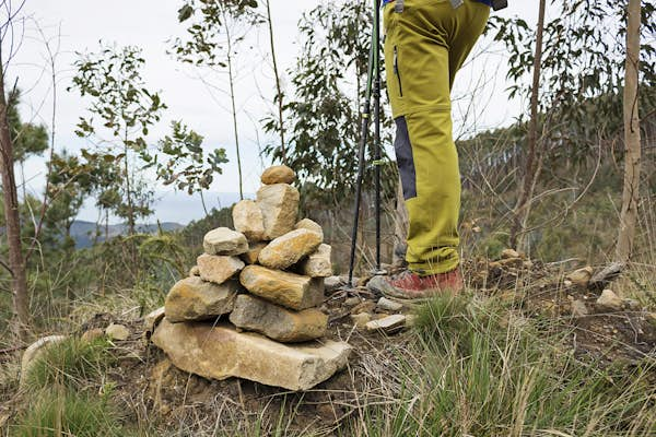
Hike far enough on just about any trail in the world, and you’ll likely spot a collection of stones placed atop each other that form impromptu sculptures. Some call them cairns. Others favor more colorful terms like “stone balancing” or “prayer stone stacks.” Whatever the name, the act of stacking rocks atop each other is ubiquitous.

Over the past decade or so, for better or worse, rock-stacking has become even more popular. What many don’t know, though, is that the practice is controversial, particularly in national parks and other protected areas. Depending on who you ask, it can be a crucial navigational device, a rewarding mindfulness practice or an environmental menace.

So, is rock stacking as harmless as it seems? Let’s dig in.

Close-up of rock cairns created by visitors in Joshua Tree National Park
Rock cairns created by visitors in Joshua Tree National Park, California. Pam Susemiehl/Getty Images

Rock stacking: from tradition to trend

Cairns were our ancestors’ first foray into building structures – pile some rocks on top of each other, and they would have the beginnings of a shelter or a food cache, for example. In Mongolia, cairns marked burial sites in cemeteries. In Tibet, Buddhists used them in ceremonies to call in good fortune and balance out conflicting energies. Before the invention of lighthouses, cairns warned sailors away from Norway’s jagged fjords.

Rock stacks became landmarks on hilltops in Scotland and trade route markers for sled dogs plowing through the Alaskan wilderness. For a time, they were a key tool in a strategy for hunting bison, used by a variety of Indigenous communities from the Rocky Mountain foothills to deep in the Dakota plains.

Today, the popularity of rock cairns has less to do with utility and tradition and more to do with social media. At least that’s the opinion of the Colorado-based rock-stacking artist, Michael Grab, who goes by the moniker Gravity Glue.

“It really started to blow up between 2014 and 2015,” he said, speaking about the trend of stacking rocks in gravity-defying formations and then posting the photos onto social media. “Then it exploded into this international art form, and what was maybe a handful of practitioners became hundreds.” Others followed, stacking rocks on beaches, on hiking trails, and, much to the chagrin of conservationists, in places where visitors are specifically asked to “leave no trace.”

Backpackers hike past cairn, marking the trail
Cairns can be useful in marking hiking trails – but that doesn’t mean they are always a good idea. Getty Images

When a pile of rocks points the way home

Some stackers do it to mark a trail, especially in less frequently navigated backcountry, and a well-placed cairn can indeed save lives. For that reason, Michael Larson, a public information officer with the US National Park Service doesn’t recommend kicking them over when you come across them, despite what you see on TikTok or online hiking forums. He points to certain locations where cairns are part of official policy.

“Carlsbad Caverns National Park uses cairns for safety to assist visitors with finding trails in remote areas of the park’s backcountry,” he said. Along volcanic landscapes in the jagged terrain of Hawaiʻi Volcanoes National Park, where cairns are still known by their traditional name, ahu, they’re also sometimes set up by park rangers, particularly in the most remote sections.

So, before you start kicking cairns over, consider why they were set up in the first place. There’s a good chance a park ranger stacked the rocks for safety reasons.

Cairns mark the trail from Elephant Hill to Chesler Park in Canyonlands National Park, Utah
Cairns mark the rugged trail in Canyonlands National Park, Utah. Getty Images

The arguments against cairns

Besides potentially confusing lost hikers, critics say rock-stacking can be culturally insensitive to past and present residents of the area. They also point to the cumulative effects disruptions can have on ecosystems underfoot.

On mountain trails, critics have said that when even a few stacked rocks fall, it can trigger cascades that could hurt unsuspecting hikers below. Even when they’re arranged to be completely safe, many nature photographers and other lovers of the outdoors simply say they’re an eyesore, distracting from the untouched environment.

A hand setting a stone atop a cairn stone pile
Official rules around cairn-building can vary depending on location. Peter Lourenco/Getty Images

Read the rules

While the National Park Service at times employs rock-stacking as part of its route-marking system, in most parks, the agency prohibits people from adding their own cairns. Like carving initials into a tree, leaving trash at a campground or spray-painting your name on a boulder, rock-stacking in most (but not all) national parks is punishable under the same laws that protect these places against vandalism and littering.

To differentiate official markers from impromptu ones, the National Park Service recommends that visitors check with park rangers for information about the design and materials used in the creation of any cairns along trails.

“We always encourage visitors to have a plan to find their way in park wilderness,” said Jonathan Shafer, the public affairs specialist for Zion National Park. He also emphasized that cairns should never be your only navigation tool. “Especially in remote areas, it’s important to have wayfinding tools like maps and a compass or GPS to navigate.”

A rock cairn in the middle of a river
If building a cairn, return the rocks to where they were once you’re finished. Daniel Hanscom/Getty Images

So, is rock stacking bad?

On its own, rock stacking isn’t always a harmful practice, though it can be. For many people, it can also be therapeutic or even an artistic outlet. In the most remote locations on Earth, cairns can literally save lives. Always follow local regulations and don’t do it in national parks or other protected lands.

If you do feel the urge to sit on the side of a trail or a riverbank and build something, when you’re done, be like Grab and follow a leave-no-trace policy.

“I take it down when I’m finished to close the loop,” he said, even when he’s built an improbably stacked rock tower.