healthyng

Category Wildlife and Nature

The 8 best places to visit in Oman

Oman’s vibrant cultural heritage is deeply intertwined with the gifts of its terrain, and it permeates every travel experience here.

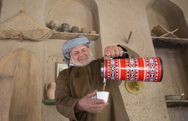
The country’s stories are found everywhere you go, from the atmospheric lanes of Mutrah Souq in Muscat, where ornate khanjars (traditional daggers) and patterned kumma (headpiece worn by Omani men) showcase excellent craftsmanship and pride, to the cliffside villages of Jebel Akhdar where old men in sandals expertly navigate narrow farm trails and distill rose water in silver bowls. Every encounter in Oman evokes a strong sense of the land.

Few visitors realize that the history of the Sultanate of Oman dates back 10,000 years. Archeological finds and relics from the Neolithic period point to the presence of ancient settlements involved in the frankincense trade.

In the 17th century, Omani control of maritime routes and ports extended from the coasts of Persia (present-day Iran) to East Africa. Today, the country is known for its reverence for its natural landscapes and its perfect balance of tradition and modernity.

Here are the best places to visit in Oman.

Sultan Qaboos Grand Mosque in Oman
Get wrapped up in the architectural details of the Sultan Qaboos Grand Mosque in Muscat. Naufal MQ/Getty Images

1. Muscat

Marvel at the effortlessly charming capital

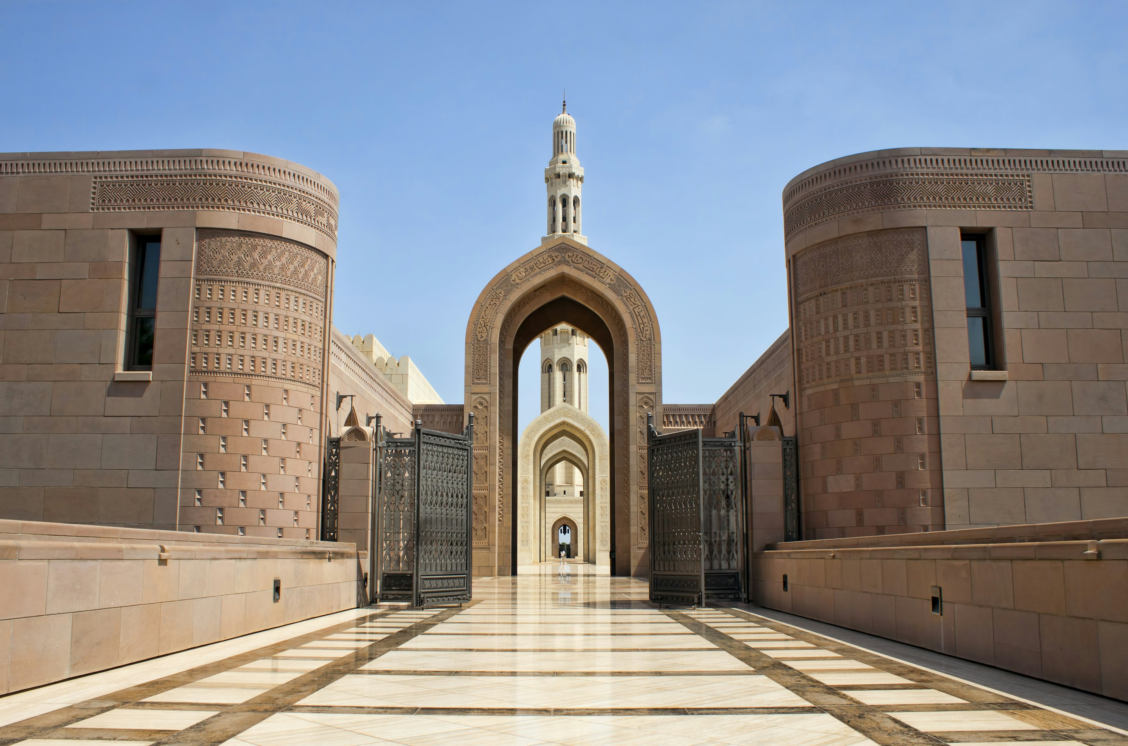
In Muscat, stone forts with watchtowers and mansions with latticed balconies stand alongside low-rise buildings and contemporary architectural masterpieces, and it all fits together effortlessly. The capital of Oman has much to see, including charming museums in restored old houses, courtyard restaurants and swanky shopping malls. The Sultan Qaboos Grand Mosque, with its arched walkways, colorful mosaic tiles, ornate dome and Swarovski-crystal-studded chandelier, is an impressive example of modern Islamic architecture.

At the Royal Opera House, take a guided tour to learn about the contemporary architecture inspired by historical fortresses. Check the schedule for showtimes: the venue hosts renowned productions from around the world. The Royal Opera House’s dress code requires suits or dinner jackets for men, dresses below the knee for women and no jeans, T-shirts or tennis shoes.

Admire whitewashed houses and blue-domed mosques along the 3km (1.9-mile) seafront promenade at Mutrah Corniche. Stroll toward Mutrah Fish Market for a closer look at the calligraphy-inspired slatted canopy roof and step inside to see the catch of the day. At Mutrah Souq, one of the oldest markets in the Arab world, you’ll find shops selling frankincense, lamps, local attire, pashminas, oud (perfume made from agarwood) and handmade sandals.

A turret at Jabrin Castle in Bahla
Beyond the ancient fort, don’t miss the 17th-century Jabrin Castle in Bahla. Getty Images

2. Bahla

Home to the legendary fort and pottery

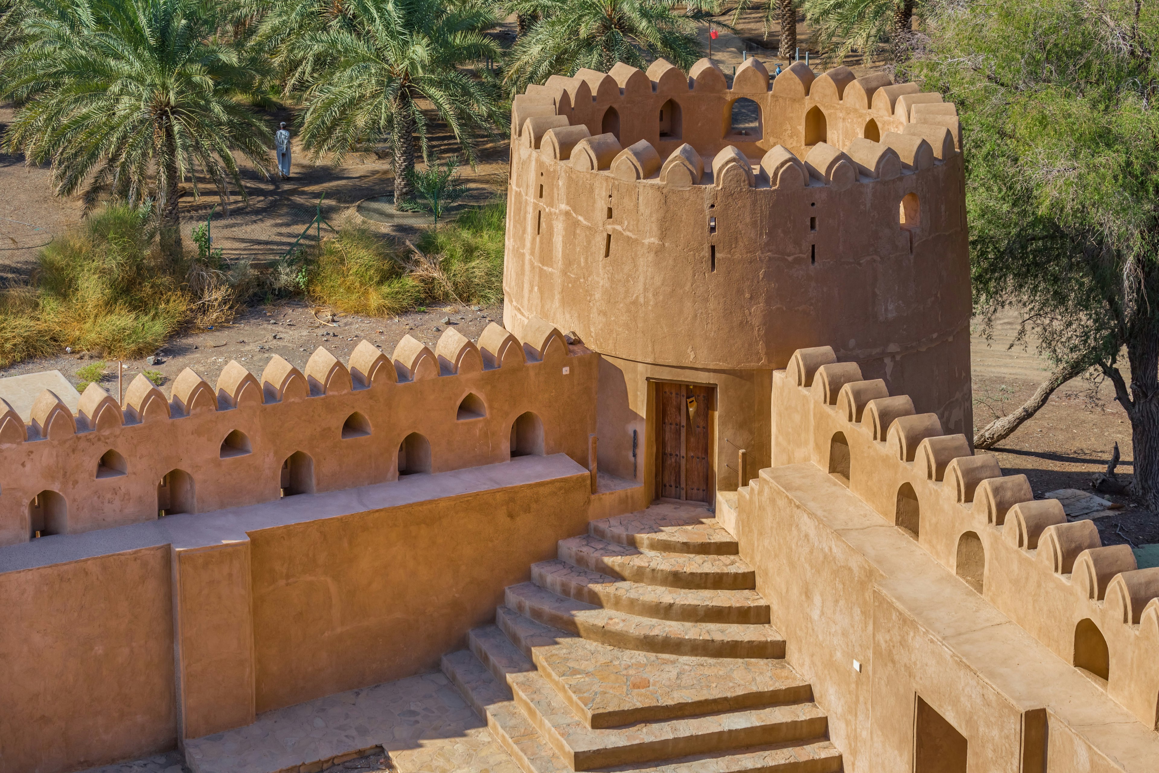
The fortified oasis town of Bahla, where local legends and myths abound, is a must-visit for Bahla Fort, a UNESCO World Heritage Site. Within the labyrinthine fort complex, built between the 12th and 15th centuries by the Banu Nebhan tribe and then expanded by subsequent ruling dynasties, you’ll find wind towers, mosques, houses and wells. Legend has it the tribe asked jinn (genie; powerful spirits in pre-Islamic Arabian mythology) to build the fort in a single night when the tribe was under threat of attack. The fort has fantastic views over old mud houses and ruins in the village, surrounded by date plantations.

Bahla is also famous for pottery crafted using mud kilns, and local potters are believed to be blessed with particularly skilled hands. You can browse pottery, jewelry, handicrafts, rugs and other wares at the Bahla Old Souq, and you might also be able to see potters in action at a workshop nearby.

Don’t miss the 17th-century Jabreen Castle a short drive away, worth visiting for its many rooms and reception areas, intricately latticed windows, painted ceilings and a date storeroom.

3. Nizwa

A city with a strong religious and cultural heritage

Visit the town of Nizwa, the capital of Oman in the 6th and 7th centuries, where the domes and minarets of mosques rise over sand-colored buildings surrounded by the Hajar Mountains. Owing to its inland location (versus that of Muscat on the coast) that limited outside influences, Nizwa has always had a strong connection to its religious and cultural heritage.

The 17th-century Nizwa Fort, with its round watchtower and high walls, protected the town from invaders over the Sultanate’s history and is a major tourist sight. At the nearby Nizwa Souq, shop for silver jewelry, delal (traditional coffee pots), saffron, dates and spices.

A 10-minute drive away, Falaj Daris Park, a UNESCO World Heritage Site, is a great spot to see a falaj channel, an ancient but highly efficient irrigation method. This one, among nearly a hundred others, waters Nizwa’s 8km (5-mile-long) palm oasis and surrounding agricultural farms.

A man snorkels in front of a large wooden tourist boat in turquoise waters surrounded by sand-colored cliffs
Explore the fjord-like inlets of Oman’s Musandam Peninsula. Andrew Montgomery for Lonely Planet

4. Musandam Peninsula

Where mountain peaks rise from the sea

The draw of the Musandam Peninsula is the sublime landscape of jagged peaks of the Hajar Mountains rising from the turquoise sea, leaving narrow inlets of water in between, a sight that has been compared to the fjords of Norway.

A boat trip on a traditional dhow (wooden boat) is the best way to experience the Musandam Peninsula, visiting islands and spotting a dolphin or whale in these waters. The town of Khasab is a good base from which to arrange a boat tour or snorkeling trip, or a mountain safari by 4WD to Jebel Harim. If you’ve got more time, other villages, wadis and fjord-like inlets such as Khor Najd are ready to be explored.

5. Jebel Akhdar

Cooler temperatures and roses at Green Mountain

At 2980m (9777ft) up in the Hajar Mountains, Jebel Akhdar – whose name translates to Green Mountain – is one of the most beautiful places in Oman. It’s also one of the coolest, with ​​the temperature being about 15°C (59°F) cooler than Muscat throughout the year. The mountain even sees some snowfall in winter.

Around Jebel Akhdar, you’ll find quiet Omani villages (some abandoned), slopes covered with terraced farms watered by falaj channels and orchards of pomegranates, peaches, apples, apricots and walnuts. In the spring, Jebel Akhdar is covered by pink Damask roses. The distilled rose water is used in cooking and as a fragrance.

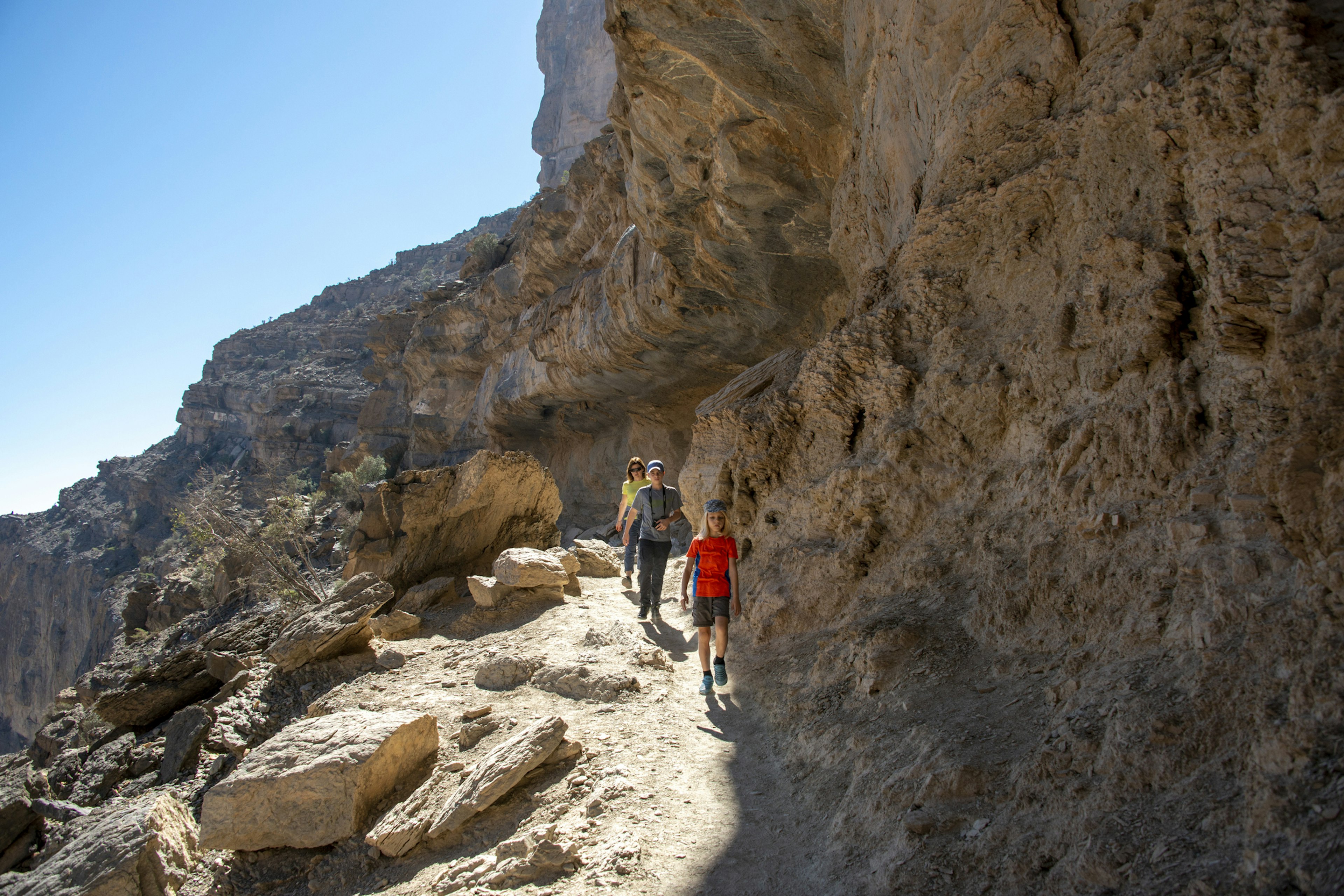
Walkers will find a few marked trails of varying difficulty, and some involve descending steep steps. Guided hikes are also available. From the Saiq Plateau, enjoy breathtaking views of the villages, and terraced farms. You can also traverse the mountain face using a via ferrata (mountain route) during a guided hike with Alila Jabal Akhdar.

A family group hiking along a rocky path in the edge of a canyon
Jebel Shams is popular with hikers, with trails through villages, farms and plantations. Paul Biris/Getty Images

6. Jebel Shams

Enjoy remarkable views in the Hajar Mountains

Go to Jebel Shams, the country’s highest peak at 3009m (9872ft) in the Hajar Mountains, for a picnic on the plateau with dramatic canyon views. Hikers can head out on an adventure through the canyons of Wadi Ghul and Wadi Nakhr, surrounded by rugged limestone walls. The Balcony Walk is a five-hour hike on an old donkey trail, now marked, with remarkable views along the rim, that ends in the abandoned village of As Sab. Other trails bring you to villages, farms, date plantations and natural pools hidden among the rocky landscape. Local operators, such as Husaak Adventures, offer one- or two-day guided hikes to summit Jebel Shams.

7. Dhofar

Explore a region rich in frankincense

From late June to early September, the khareef, the monsoon from the Indian Ocean brings a certain romance to the lush landscapes of Salalah. The pleasant weather makes it one of the best places to visit in Oman in summer, when temperatures elsewhere in the country can reach above 40°C (104°F) on the hottest days. This coastal city is an excellent base from which to explore the wider Dhofar region.

Salalah has plenty of sights to visit. The Sultan Qaboos Mosque, the largest mosque in Dhofar with its two domes and twin minarets, is a great example of Islamic architecture, and it’s open to non-Muslims from 8am to 11am Saturday to Thursday. Make the obligatory photo stop outside Al Hosn Palace, the Sultan’s palace complex, before wandering into Al Hosn Souq to follow the aromas of spices and frankincense.

Join local families picnicking on the white-sand Al Mughsail Beach, and watch geysers of seawater erupt from the ground at the Mughsail Blowholes. The surrounding region is home to natural springs and wadis (valleys). At Wadi Darbat, a walk past monsoon-fed waterfalls and grazing cattle or a boat ride on Darbat Lake is a great way to see the rain-drenched valley.

Woven into the story of Dhofar is its rich heritage of frankincense, an aromatic resin harvested from the Boswellia sacra tree, which has been used to make perfume and medicine, and in religious rituals, for thousands of years. Dhofar was at the center of frankincense production, and its rare and highly prized frankincense was coveted from China to the Mediterranean and North Africa.

To learn more, visit the Wadi Dawkah nature reserve where you’ll find hundreds of frankincense trees from which the resin is still harvested. At the archeological sites of Khor Rori, Al Baleed and Ubar, the ruins of fortified medieval towns tell of frankincense-trading caravans and settlements. Together, these sites, some dating to the 4th century BCE, constitute the Unesco World Heritage Site known as the Land of Frankincense.

The mountains of Jebel Samhan offer spectacular views and are home to a protected reserve with Arabian leopards, Arabian gazelles and other indigenous wildlife.

A single figure stands on a sand dune staring off into the desert
The desert landscape of Sharqiya Sands in Oman seems infinite. Chalabala/Getty Images

8. Sharqiya Sands

Visit the undulating dunes of the desert

No trip to Oman is complete without a visit to the desert. At Sharqiya Sands, also known locally as Wahiba Sands, you’re surrounded by undulating dunes and desert vegetation in a seemingly infinite landscape that feels like it was crafted out of gold when the sun is low in the sky. These wind-sculpted dunes, some as high as 100m (328ft), continue on into the famous Empty Quarter, one of the largest sand deserts in the world.

While Bedouin (known in Arabic as Bedu, meaning desert dweller) still live and work here (many as guides), the Wahiba Sands are also popular with local families and tourists. Visitors come for a day trip or an overnight stay in one of many camps offering varying levels of luxury and amenities such as Thousand Nights Camp and Magic Camps. Staying overnight gives you the chance to experience the quietness of the desert after the day-trippers have left, partake in Bedouin traditions around a bonfire, feast on traditional dishes and stargaze in one of the most pristine landscapes in the region.

The 9 top things to do in Valais, Switzerland

Vertiginous ravines, 4000m (13,100ft) peaks and an monumental glacier are Valais’ calling cards.

Anchored by the soaring pyramid of the Matterhorn in southwest Switzerland, this canton abounds with Swiss icons – think ridiculously handsome mountains, warm and gooey AOP Raclette de Valais cheese and slobbery St Bernard dogs.

This is where the world’s most storied little red train, the Glacier Express, pulls out of Zermatt on its mythical journey east through 91 tunnels and 291 bridges to St Moritz. This is where ski fiends fly down moguls the size of small cars on Champéry’s “Mur Suisse” (Swiss Wall) and powder hounds carve the first tracks in Verbier. It’s where locals speak both Swiss German, in the east – and French, to the west and across and the invisible Röstigraben (Switzerland’s linguistic divide).

In short: Valais is Switzerland distilled, and where you can expect the ride of a lifetime – and one like no other. Here are nine places you’ll want to add to your itinerary.

Valais, Switzerland is one of the best regions to visit next year. See our full list of Best in Travel 2025 winners.

Early morning dawn scene of sunrise on the Matterhorn Mountain reflecting pink in the lake with male man on rock with red down jacket with clear blue sky, Zermatt
You’ve seen it on postcards, yes – but nothing prepares you for your first in-person view of the Matterhorn. Getty Images

1. Zermatt

Best spot for Matterhorn adoration

Though it’s one of the most famous mountain views in the world, nothing prepares you for that first intoxicating glimpse of Zermatt’s emblematic peak, which rises like a shark fin above the historic mountain town. From the second you step off the train (Zermatt is car-free), looking repeatedly up toward the Matterhorn for a view of its hooked 4478m (14,690ft) summit without clouds swirling around it becomes an obsession. Matterhorn aside, this glittering Grand Tour favorite seduces pretty much everyone – from summertime walkers to style-conscious skiers, families to couples on a romantic weekend – with exciting Alpine history, spectacular scenery, glitzy window shopping, nightlife and year-round glacier skiing. There is no other place like it in the world.

Planning tip: Don’t leave town without riding three cable cars up to Klein Matterhorm (3883m / 12,740ft) – the 360-degree panorama of 14 glaciers and 30-plus peaks above 4000m (13,123ft) will blow your mind – or Europe’s highest cog-wheel railway to Gornergrat (3089m / 10,135ft).

2. Sion

Best town for a weekend break in fall

If you didn’t grow up in Valais, you probably won’t have heard of this disarmingly bewitching toy town. While French-speaking Sion is wedged on the floor of the Rhône Valley, its pair of châteaux – which have crowned two craggy hillocks since the 13th century – scream medieval drama. Combine château visits (the town has four) with a wander around its tiny Vielle Ville (Old Town) and tastings of local white Fendant wine in old-school cafes evocative of la belle France. Sion is also a brilliant base for unusual day hikes along Valais’ signature bisses – miniature canals ingeniously engineered from the 13th to 15th centuries to irrigate the steep, gravity-defying, terraced vineyards surrounding the town.

Planning tip: Time your visit with the vendange in September, when grapes in vineyards around Sion are harvested, leaves blaze red, and chefs everywhere cook up chamois, venison and other seasonal game. Buy a Valais Wine Pass (Sfr49) at the Sion tourist office, which will score you 10 glasses of wine at tasting cellars around the region.

alt text

The best way to stay connected.

Saily provides a hassle-free solution to travel data — just choose your data plan and prepare for your trip. When you get to your destination, you can go online right away.

Get your eSIM

A woman on a viewing platform watches the sunrise at Mont Fort, Switzerland
The sunrise view from Mont Fort is always extraordinary. Shutterstock

3. Verbier

Best resort for adrenaline junkies

Valais’ other world-renowned ski town, old-monied Verbier is small, expensive and cut at all the right angles to dazzle. This is where Europe’s glitterati come to cruise down slopes in the superlative 4 Vallées ski area, then hobnob behind closed doors in VIP lounges, swank clubs and palatial private chalets.

But there’s another side to Verbier that attracts hard-core adrenaline junkies in droves. Free-riding here in knee-high powder is exceptional – and the thrills don’t end in summer, either. From June to October, grab a bike, helmet, wheels and body “armor” to burn rubber in the Verbier Bikepark. It’s not for nothing that the competition track in the downhill mountain-bike park is called Tire’s Fire.

Planning tip: Not feeling it? Rent an e-bike or ditch the hard-core action altogether for a leisurely ride by cable car to Mont Fort (3300m / 10,827ft), Verbier’s highest peak. We especially recommend going at dawn, when the sun rises over pink peaks.

Chalets and charming traditional houses line a hillside in the village of Grimentz, Valais
Delightful Alpine villages are yours to discover along the Val d’Anniviers’ winding roads. Steven Van Aerschot/Shutterstock

4. Val d’Anniviers

Best valley for scenic road-tripping

It is easy to get off the grid in Valais. Following this peaceful side valley’s corkscrew roads on an e-bike or car along will bring you past geranium-festooned Alpine villages, charming chapels and mazots (larch-wood huts), where farmers and winegrowers once stored their tools. Lunch with a Matterhorn view at Hotel Bela Tola in the village of St-Luc is a quintessential Swiss pleasure. You can also bake bread in the village’s pain au four (bread oven), sip rare “glacier wine” direct from the barrel in a cellar further up the valley in Grimentz (1553m / 5095ft), or bathe in velvety taupe mud and milk-blue glacial water by the Moiry Glacier.

Local tip: In summer, hop aboard a canary-yellow Postbus in Grimentz for a tour of the side valley in this 1940s-era open-top vehicle.

Two trekkers walking on Aletsch Glacier, Valais, Switzerland
Hook on your crampons to take the surface of majestic Aletsch Glacier. Pete Seaward for Lonely Planet

5. Aletsch Glacier

Best glacier for big-thrill ice hikes

Gazing from afar at this jaw-dropping natural marvel – the Alps’ longest glacier
and a UNESCO World Heritage Site – has been a traveler’s rite of passage since the birth of tourism. But it is only in Valais that you can get up close – and without the crowds, too. Streaming in a curve around Aletschhorn (4195m / 13,763ft), the second-highest peak in the Bernese Alps, the 20km(12.5-mile)-long sea of ice can accessed by cable car from riverside hamlet Fiesch (2212m / 7257ft). For outdoor enthusiasts and anyone interested in our world’s fast-melting glaciers, a guided summer trek on the ice – roped to a guide and wearing crampons, with crevasses and the unsettling rumbling of water flowing deep beneath your feet – is spellbinding. Ditto for ski-touring treks in winter.

Planning tip: Book glacier hikes (ages 10 and up) with the Aletsch Mountaineering Centre in Fiesch. No mountaineering experience is required – just sure-footedness and a reasonable fitness level.

6. Bettmeralp

Best ski resort for car-free cool

In keeping with Valais’ increasingly green ethos, there is only one way to access this family-friendly mountain hamlet: by cable car, from the Rhône Valley floor far below. Emerging up top at 1900m (6234ft), winter skiers cross into a storybook world of snowy streets, a whitewashed chapel on a hillock, little ones (or the week’s groceries) being pulled along main street on old-fashioned wooden sledges…and not a car in sight. Consider it the stuff of Swiss Alpine dreams. Downhill skiing on 64 miles (104km) of wide slopes in the Aletsch Arena ski area couldn’t be better for beginners and intermediates, or for skiers on the mountain simply to feast on the mind-blowing glacier views.

A view looking down on the hairpin turns of the Furka Pass through the Alps, Switzerland
Tackle the winding Furka Pass behind the wheel – if you dare. Tanase Sorin/Shutterstock

7. Furka Pass

Best mountain pass for van life

Immortalized in a car chase in the 1964 James Bond classic Goldfinger, the Furka Pass in Valais’ far northeastern corner is Switzerland’s king of alpine passes. Open since 1867, it swerves around countless hairy hairpins and the 007-famous Hotel Belvédère (now closed) to Andermatt in central Switzerland. Serious road trippers seeking no mercy can either make a glorious loop of it by tacking on the Susten (2260m / 7415ft) and Grimsel (2164m / 7100ft) mountain passes before heading on to Furka (a 75-mile round trip), or hit the high road south into the Italianate canton of Ticino via the impressively barren and remote Nufenen Pass (2478m / 8130ft).

Two St Bernard dogs (Katy and Salsa) pose at the Great St Bernard mountain pass, Switzerland
In Martigny, you can get up close the region’s most famous canines: slobbery, irresistible St Bernards. Fabrice Coffrini/AFP via Getty Images

8. Martigny

Best town for culture vultures

Time spent in Valais’ oldest town and French-speaking capital shines light on why the Romans lingered here en route across the Col du St Bernard to Italy. Away from its rather ugly new town, Martigny boasts a Roman amphitheater, terraced vineyards and a cute medieval center. Sculptures by Rodin, Henry Moore and other modern masters pack out its top-drawer art museum, and views from the town’s 13th-century hilltop château spread out as far as the eye can see down the Rhône Valley. The surprise pièce de résistance? The Barryland museum complex and kennels, which celebrate Switzerland’s slobbery and completely irresistible lovable St Bernard dog.

Planning tip: Around Martigny, Sundays in March herald the start of the cow-fighting season, when Valais’ prized Hérens cows lock horns in the traditional head-butting quest to be “queen” of the bovines.

9. Sierre

Best town for wine culture

Château-dotted vines rise high above the small town of Sierre, the start or end point for the Sentier Viticole (Vineyards Trail). Two wine museums – Sierre’s Musée Valaisan de la Vigne et du Vin in 17th-century Château de Villa and Salgesch’s Weinmuseum – bookend the 3.7-mile walk, which is dotted with educational panels about the pinot noir vines and wines they yield. The trail can be walked in either direction, with both ends roughly half a mile from Sierre or Salgesch train station.

Planning tip: To buy wine and lunch in style, end in Sierre at the Oenothèque wine cellar in Château de Villa, where you’ll find 630 different Valais wines and a restaurant cooking up a tasting of five local Raclette cheeses.

First-timers guide to snorkeling and scuba diving on the Great Barrier Reef

A ribbon of color and life providing a habitat for more than 9000 marine species, the Great Barrier Reef is an Australian icon. Despite increasing threats to its survival, the world’s largest living organism – stretching along the Queensland coast for over 2300km (1429 miles) – continues to dazzle visitors with its surreal underwater scenery from tip to tail.

The sultry northern Queensland city of Cairns is the most famous gateway to the Great Barrier Reef, but there are plenty of other access points and an ever-increasing number of ways to experience this World Heritage-listed wonder and its 2900 individual reefs. Plan your first visit with Lonely Planet’s ultimate guide.

Snorkelers, Great Barrier Reef, Australia
The best time to visit varies across the 2300km-long Great Barrier Reef © artincamera / Shutterstock

When is the best time to visit the Great Barrier Reef?

The best time to visit the Great Barrier Reef is generally from June to November.

From December to March, northern Queensland (north of Townsville) has its wet season, bringing oppressive heat, abundant rainfall and the occasional cyclone – but you will find bargains on reef tours and accommodation. Stinger (jellyfish) season is between November and May, with Lycra stinger suits provided to snorkelers and divers for protection.

However, anytime is generally good to visit the Whitsundays (usually accessed from Airlie Beach) and the southern Great Barrier Reef (from Great Keppel Island near Yeppoon, south to Lady Elliot Island). Nature’s calendar is useful for timing your trip, with key events including the whale migration (during the winter months of June to October), turtle nesting and hatching (November to April, which is spring to autumn time in Australia) and coral spawning (a few days per year between November and December). Manta rays are particularly abundant around Lady Elliot Island in the Australian winter.

How much time do I need to see the Great Barrier Reef?

You can experience the Great Barrier Reef in as little as half a day from most land-based hubs along Queensland’s coast, but you’ll need a full day to experience the outer reef, home to more impressive diving and snorkeling spots.

Liveaboard dive boats visit the most spectacular reefs; most depart from Cairns and run for one to seven nights.

Further south, sailing trips in the Whitsundays are another popular way to experience the Great Barrier Reef Marine Park. Standard trips run for two nights/three days and include snorkeling stops and optional introductory dives.

Nudey beach on Fitzroy island near Cairns in Queensland, Australia
Base yourself on an island like Fitzroy Island near Cairns for a more secluded experience © John Crux Photography / Getty Images

Can I stay on the Great Barrier Reef?

It’s possible to stay on many of the reef’s 1050 islands and coral cays. Wake up with the reef on your doorstep at an island-resort base such as Lizard Island (accessed by plane from Cairns), Green or Fitzroy Island (accessed by boat or ferry from Cairns), the Whitsundays (fly to Hamilton Island or take a ferry from Airlie Beach), Heron or Wilson Island (accessed by barge from Gladstone) or Lady Elliot Island (accessed by plane from Bundaberg, Brisbane or the Gold Coast), to name a few.

You can also stay in pontoon-based accommodation managed by Cruise Whitsundays and Lady Musgrave Experience (operating from Bundaberg).

Is it easy to get to the Great Barrier Reef?

Cairns and the nearby resort town of Port Douglas are the main launching pads for reef tours, with myriad operators offering everything from half-day trips on large boats to intimate multi-day luxury charters. Cairns has an international airport, with transfers available to Port Douglas.

South of Cairns, reef tours also run from Mission Beach, Townsville, Airlie Beach and the Whitsundays, Bundaberg, Mackay, Yeppoon, Gladstone, Agnes Water and the town of 1770, and Bundaberg. Most of these hubs have domestic airports, and the Spirit of Queensland connects Brisbane to Cairns by rail. It typically takes between 90 and 120 minutes by boat to reach the outer reef. Tours on large catamarans (read: less likely to trigger seasickness) depart from Cairns, Port Douglas, the Whitsundays and Bundaberg.

Sugar Wharf in Port Douglas. Photo by Stoneography / Getty.
There is plenty to do on land as well as out on the reef: Port Douglas at sunset © Stoneography / Getty Images

Top things to do at the Great Barrier Reef

Diving and snorkeling is a highlight for most visitors to the Great Barrier Reef, but there is a range of other ways to experience this aquatic wilderness.

See the reef without getting wet on a scenic small-plane or helicopter flight from Cairns or the Whitsundays. Non-swimmers can also view the reef from glass-bottom boats, semi-submersibles and underwater observatories at pontoons visited on day trips from Cairns, Port Douglas, the Whitsundays and Bundaberg. Or simply enjoy the island scenery on a Whitsundays sailing tour.

On land, Indigenous-guided tours offer a memorable opportunity to learn how Aboriginal and Torres Strait Islander peoples have lived in harmony with the reef for time immemorial, with a rich range of options in Cairns. You can also explore the reef with Indigenous guides on a day trip with Cairns-based Dreamtime Dive and Snorkel.

Cairns and Port Douglas are also great bases for visiting the lush Daintree Rainforest. At the southern end of the reef, learn about sea turtles at Bundaberg’s excellent Mon Repos Turtle Centre, then join a ranger-led tour (November to March) to see green and loggerhead turtles nest or hatch.

Where’s the most child-friendly place to stay at the Great Barrier Reef?

Many families gravitate to the abundance of family-friendly resorts and reef tour options in Cairns and Port Douglas. In the Whitsundays, Hamilton Island and Daydream Island Resort offer family-friendly island bases, and Airlie Beach has a wide range of caravan parks for road-tripping families.

Many boat trips to the outer reef visit family-friendly pontoons including Reef Magic opened near Cairns in 2022. Here nervous snorkelers can view fish without letting go of the platform, or stay dry and experience the reef via the semi-submarine, glass bottom boat, and underwater observatory.

How much money do I need to experience the Great Barrier Reef?

A standard day trip to the outer reef including snorkeling gear, lunch and glass bottom boat tours (if available) costs between AUD$200 to AU$350 per adult, with family rates usually available. Scuba dives can typically be added for an extra cost (budget from AUD$200 for two dives). The best deals are usually scored in Cairns, home to a wider choice of operators.

Half-day trips to the inner reef are a great way to save time and money. Some of the best snorkeling spots visited on half-day trips include Mackay Reef off Cape Tribulation (offered exclusively by Ocean Safari) and the Low Isles off Port Douglas (Reef Sprinter currently offers the cheapest tour).

One of the most affordable ways to stay on the reef is to camp on islands in Great Barrier Reef national parks including Capricornia Cayes National Park, Fitzroy Island National Park, and Whitsunday Islands National Park. The camping rate is just AUD$7.25 per night, but the cost of boat transfers can add up.

Where is the best diving and snorkeling on the reef?

There’s great diving and snorkeling along the reef’s entire length, with a rich diversity of corals, clams, tropical fish, turtles, rays, sharks and other critters commonly spotted from tip to tail. While the corals are more vibrant northward of Townsville, the slightly cooler southern Great Barrier Reef is generally less prone to coral bleaching. It’s also a particularly good place to see manta rays.

To access the most exquisite sections of the outer reef (including the Ribbon, Osprey, Milln, Bougainville and Holmes reefs) sign up for a liveaboard trip from Cairns. Some of the nicest reefs visited on day trips include Agincourt Reef (off Port Douglas) and John Brewer Reef (off Townsville). John Brewer Reef is also home to the Coral Greenhouse, part of an underwater installation series known as the Museum of Underwater Art.

Closer to Townsville, the century-old SS Yongala is widely considered to be one of the world’s top wreck dives.

Portrait of Great Barrier Reef dive instructor
If you haven’t got your PADI certification, you can do a course while in Australia © Matt Munro / Lonely Planet

Can I get scuba certified on the Great Barrier Reef?

The main learning centers are in Cairns, with open water courses offered by outfits like ProDive Cairns. You’ll get two days of pool and classroom training followed by two days of reef diving on day trips or three days of diving on a two-night liveaboard trip.

Advanced courses are hosted on liveaboards.

Isn’t the Great Barrier Reef dying?

It’s no secret that the Great Barrier Reef faces unprecedented threats, with approximately 73% of the 1000 reefs surveyed over the summer of 2023/24 found to be impacted by coral bleaching caused by heat stress. Other threats include coral-hungry crown-of-thorns starfish; cyclones; flooding and land-based run-off; and marine pollution.

While some parts of the reef have not recovered from bleaching events, other sections have bounced back, offering hope for the future of this dynamic ecosystem.

Visitors can help scientists monitor changes on the reef by reporting bleaching and other observations via the Eye on the Reef app. You can also support conservation efforts on a citizen science-based tour offered by the likes of Cairns-based Passions of Paradise.

What should I pack for a trip to the Great Barrier Reef?

Sun protection is vital for a trip to the Great Barrier Reef. Ensure your sunscreen is reef-safe by choosing brands that use physical UV blockers such as zinc oxide and titanium dioxide rather than chemicals such as oxybenzone and octinoxate, which can damage coral.

No matter the weather forecast, pack warm layers and rain gear. And if you plan on doing a lot of snorkeling or diving, bring your own gear to save on rental costs.

Plane view of the famous Heart Reef (Great Barrier Reef) at the coastline of Airlie Beach near the Whitsunday Islands (Whitsunday Islands, Australia)
See of the famous Heart Reef in the Whitsundays on an aerial tour © Yannik Photography / Shutterstock

What about accessible travel to the Great Barrier Reef?

The Cairns region offers the widest range of accommodation, reef tours and attractions with wheelchair access, along with support for visitors with vision and hearing difficulties or other needs.

How to stay safe on Great Barrier Reef

Tourism in the Great Barrier Reef Marine Park is tightly managed to prevent injuries to visitors and the reef. Follow safety instructions and avoid touching coral and other marine life.

There have only been a handful of fatal shark encounters on the Great Barrier Reef, and jellyfish stings can be avoided by wearing a stinger suit. Outside stinger season, wearing a rash vest, swim shirt or wetsuit can help you avoid contact with non-life-threatening stinging critters such as sea lice.

It’s rare to find saltwater crocodiles on the Great Barrier Reef, but crocs are present along nearly the entire Great Barrier Reef coast. Be croc-safe and stick to designated swimming areas.

My favorite thing to do on the Great Barrier Reef

I’ve been hooked on the Great Barrier Reef since my first visit to the Whitsundays as a child. Among my favorite experiences was a recent stay on at the reef’s southern tip. Transformed from a barren coral cay to a thriving ecosystem, the island’s relaxed, family-friendly resort runs almost entirely on solar power. I loved getting up early to snorkel with turtles on the house reef, scuba diving with manta rays, and observing rare seabirds that nest on the island.

Joshua Tree National Park: everything a first-time visitor could want to know

What makes Joshua Tree National Park so memorable? It’s a little bougie. It’s a little woo-woo. And its natural beauty is simply astonishing.

Between the Coachella Valley and the vast high desert of interior California, the park is within easy drive of marvelously midcentury playground Palm Springs and the holistic hot spot that is the city of Joshua Tree. (You don’t have to follow your hike with a martini at a Rat Pack–era lounge or a sound bath in a magical dome inspired by extraterrestrials. But you can – details below.)

The national park is where two deserts with totally different ecosystems – the Mojave and the Colorado – meet. It’s home to striking succulent-filled fields, towering rocks eroded into skull- and animal-like forms, and groves of trees with blade-like leaves.

Spend a day here and you’re less likely to ask “What desert am I in?” than “What planet have I landed on?”

And because deserts are inherently places of wonder, first-time visitors are likely to have many questions. Is Joshua Tree National Park doable as a day trip from Palm Springs? What about from Los Angeles? Will I see actual trees named Joshua? And where do I find the dome that must have been designed by aliens?

Curious? We have answers.

When should I go to Joshua Tree National Park?

As you probably guessed, desert-based Joshua Tree gets blazing hot in the summer – like, triple-digits-every-day hot. This does make May through September the low season, when you’re more likely to score deals on hotel rates. The blazing heat, however, can be dangerous, so visitors are advised to check the weather daily and stay flexible with plans, whether limiting outdoor activities to early mornings (before 9am) or evenings (after 5pm), or avoiding them altogether. The park also warns guests of increased bee activity during summer, which may persuade anyone with an allergy to visit in the cooler months.

October through April is peak season, with April being especially busy because of the Coachella Valley Music and Arts Festival in nearby Indio (about 25 miles from the park’s south entrance). While it’s always fun to mix music with outdoor adventure, you’re likely to pay an arm and a leg for lodging everywhere from Palm Springs to Pioneertown, including every Airbnb and converted Airstream in the area. Fall, winter and spring have pleasant daytime temperatures for hiking and climbing, ranging from low 60s to mid 80s (F) – but nights can get cold, especially December through February, when it can dip into the 30s.

A woman stokes a camp fire near her tent at night in Joshua Tree National Park, California, USA
If you’re on an extended visit to Joshua Tree, consider camping under the stars © Alex Treadway / Getty Images

How much time should I spend in Joshua Tree National Park?

There’s enough desert eye candy to treat your senses for a week…or much more. But if, say you’re visiting Palm Springs and want a national-park pit stop, a shorter visit can work. (For that post-hike martini back in Palm Springs, by the way, head to Melvyn’s.) A day trip from Los Angeles, however, is ambitious – to say the least. Depending on traffic (which is guaranteed in Southern California), the drive is between 3 and 4 hours each way. Count on staying overnight near the park.

If you have one day…

Stick to hiking the trails near the park’s west and north entrances, which open up to the Mojave Desert. With higher elevations than the Colorado Desert portion of the park, the Mojave is home to mind-boggling boulders and otherworldly rock formations as well as the park’s namesake trees – and you can’t visit Joshua Tree National Park without laying eyes on one.

If you have a weekend…

With at least two days, you can explore both the Mojave Desert portion of the park (mentioned above) and the Colorado Desert side, which is known for its fields of fuzzy-looking cacti. While you won’t have time to trek every foot of trail, you’ll be able to get in a few solid hikes and still have time for some scenic drives. You can also spend the night. While there are no hotels within the park, there are 500 campsites, most of which can be reserved up to 6 months in advance.

If you have a week or more…

The California desert is your oyster. Hike to your heart’s content inside the park, then branch out to nearby trails like Tahquitz Canyon near Palm Springs, home to a seasonal 60ft-high waterfall. In addition to visiting Palm Springs, sneak in a day trip to Idyllwild, a charming mountain town that’s a great respite from the desert on extra-hot days. A week is also plenty of time to explore the unique towns and quirky attractions north of the park. Visit an Old West–style town originally built as a film set in the 1940s (Pioneertown), see sculptures made from defunct TVs and toilets (Noah Purifoy Desert Art Museum in Joshua Tree) and get a sound bath at that alien-designed dome mentioned above (the Integratron in Landers).

A freshly paved road at dusk, Joshua Tree National Park, California, USA
Paved roads will take you through Joshua Tree National Park – but you’ll need a car © West Coast Scapes / Shutterstock

Is it easy to get in and around Joshua Tree National Park?

Yes – if you have a car. The park has paved roads so it’s entirely accessible, but there’s no public transportation within the park, and cell service is too spotty to count on calling for a ride. Once you’ve arranged your own set of wheels, be sure to arrive with a full tank of gas and plenty of drinking water, as there aren’t gas stations, restaurants or grocery stores in the park.

The closest airport is Palm Springs International Airport, 45 miles away.

Top things to do in Joshua Tree National Park

Stroll among thousands of teddy-bear cholla cacti

Like so many of Joshua Tree’s trails, the Cholla Cactus Garden proves that mileage isn’t the only thing that will get your heart pumping. Only a quarter-mile loop, the path teems with eye-catching cacti with fuzzy-looking limbs that almost resemble the outreached arms of a teddy bear. These plants are definitely prickly, though – so we don’t recommend going in for a hug.

Male boulderer moving up a boulder at dusk, Joshua Tree National Park, California, USA
Joshua Tree National Park is a hub of rock climbing and bouldering © Manuel Sulzer / Getty Images

Scale a monzogranite rock formation

All those captivating crags and bewitching boulders aren’t just pretty scenery. Joshua Tree National Park draws rock-climbing enthusiasts of all levels to its more than 8000 climbing routes. Hiring a guide, especially if you’re new to the sport and/or the park, is always a good idea. Cliffhanger Guides, Joshua Tree Guides and Stone Adventures all offer half-day and full-day adventures.

Hike a historical gold mine

What today is an area of hiking gold was once a literal goldmine. Over the course of about 40 years in the last century, Lost Horse Mine produced today’s equivalent of $5 million in silver and gold, making it one of the most successful mines in the park. These days, the tunnels and mill are fenced off, but you can still see artifacts and ruins in the area, including stone houses where the miners lived. Out and back, Lost Horse Mine Trail is 4 miles, or you can take a looping route that’s 7 miles total.

Get a glimpse of the Milky Way

Thanks to very little light pollution, Joshua Tree is one of the rare International Dark Sky Places in the USA – which means it’s a prime place for stargazing. The park has four designated stargazing areas that are especially dark: the parking lots of Quail Springs, Hidden Valley, Cap Rock and Ryan Mountain.

A woman standing on a large boulder overlooking Hidden Valley Trail, Joshua Tree National Park, California, USA
The Hidden Valley Nature Trail offers fabulous photo opps without too much effort © Dan Hanscom / Shutterstock

My favorite things to do on a Joshua Tree National Park trip

Get maximum hiking excitement for minimal sweat

The photos will show your family and friends that you scaled gargantuan granite boulders beneath the Mojave Desert sun. But they don’t have to know the hike was only a mile. That’s why I’m a huge fan of the Hidden Valley Nature Trail: an easy, flat loop that’s doable for even my 1-year-old from the comfort of his stroller. But the views and opportunities for scrambling up rock formations make you feel like a true adventurer, no matter your age.

Stay at a souped-up roadside motel

In recent years, California has been in the midst of a motel renaissance, with hoteliers rehabbing atmospheric if simple properties dating to the 1940s and ’50s. These resurrected roadside palaces are my preferred accommodations around Joshua Tree: they feel as timeless as a national park getaway. Take your pick from Pioneertown Motel, ​​where legend has it Gene Autry played poker from sundown to sun up in room #9; Harmony Motel, where U2 was photographed in their Joshua Tree era; and Mojave Sands, renovated by a former furniture maker for Marc Jacobs.

Catch a concert at a saloon-style music venue

Another reason I like to stay at the Pioneertown Motel: it’s a 2-minute shuffle from there to Pappy & Harriet’s, a former cantina and biker bar that now hosts musicians like Orville Peck and Patti Smith for intimate performances. Even if you don’t come for a concert, you can still stop in for barbecue, burgers and cactus-flower cocktails.

People dining at Pappy & Harriet’s restaurant and music venue, Pioneertown, California, USA
Pappy & Harriet’s is a Pioneertown cantina that often houses famous music acts © BrianPIrwin / Shutterstock

How much money do I need for Joshua Tree National Park?

Both in terms of activities and your budget, Joshua Tree National Park is a choose-your-own-adventure kind of place. You can splurge on a house with a pool, or snag a campsite for only slightly more than your breakfast burrito. A heads up: hotels and house rentals in Palm Springs skew more expensive than those in the high desert. Within the latter, lodging in Twentynine Palms offers better value than Pioneertown or Joshua Tree town.

  • Joshua Tree National Park entrance pass: $15 per person per week for those entering on foot or bike; $30 per private vehicle per week, including all passengers

  • Campsite in the park: $15–25 per night

  • Campsite outside the park: $44 pernight

  • High desert hotel room: $150–300 per night

  • Palm Springs hotel room: $250–600 per night

  • High desert three-bedroom home rental: $250–350 per night

  • Palm Springs three-bedroom home rental: $500-$600 per night

  • Cup of coffee: $4

  • Breakfast burrito: $12

  • Burgers and fries for two: $35

  • Beer at a bar: $7

  • Cactus flower cocktail: $14

  • Souvenir t-shirt: $25

  • Half-day rock-climbing guide: $138 per person (for group of four)

  • Tickets for a Concert at Pappy & Harriet’s: $70

  • Public sound bath at the Integratron: $55 per person

The Milky Way shines over a Joshua tree in Joshua Tree National Park, California, USA
Visit the park after dark to gaze at the astonishing stars above © Etienne Laurent / AFP via Getty Images

Frequently asked questions about Joshua Tree National Park

Are some of Joshua Tree National Park’s three entrances busier than others?

The west entrance, near the town of Joshua Tree, is the busiest, with waits up to an hour on weekends during peak months. Exiting here also gets busy just after sunset. Near Twentynine Palms, the north entrance is less busy; the south entrance, near Cottonwood Spring, is usually the least crowded.

Are there picnic areas in Joshua Tree National Park?

Get your breakfast burritos to go: the park has eight picnic areas (Cottonwood, Indian Cove, Live Oak, Split Rock, Cap Rock, Hidden Valley, Quail Springs and Black Rock).

What time does Joshua Tree National Park close?

It doesn’t! The park is open 24/7, making it especially great for stargazing.

What should I pack for Joshua Tree National Park?

Pack plenty of layers, especially if you’re visiting in the winter when daytime weather may be sunny and 65°F – but dipping town as low as the 30s come night. A sizable water jug, comfortable hiking shoes, sunscreen and a hat are also key.

Was the album art for The Joshua Tree by U2 shot in the park?

The bad news: no. The good news: no need to waste your time searching for the famous cover tree. The desert landscape featuring a lone Joshua tree (Yucca brevifolia), featured on the inside cover of the album, was actually shot about four hours north of the region, much closer to Death Valley National Park. Sadly, that particular tree is no more. But a dedicated fan dropped a bronze plaque in its place inscribed with the question, “Have you found what you’re looking for?”

A first-time guide to São Tomé and Príncipe

Off Africa’s west coast, the archipelagic nation of São Tomé and Príncipe is one of the continent’s most special secrets.

Made up of two main islands, São Tomé and Príncipe offers the best of tropical paradise: long and deserted beaches fringed with palms and a plethora of activities to help you access all this beauty.

But there’s something more here – in a word, harmony. On these islands, nature holds sway and the people move in respectful tandem with the natural world, those who make the long trip here will find superb landscapes and a tourism industry in sync with the surroundings.

Expect quiet pleasures, like lingering over a banquet of moqueca de peixe (fish stew) and gloriously named blá-bla (smoked fish) while gazing out over the Atlantic. Hiking through a forest, finding a beach and being the only one there.

Interest piqued? Read on to learn more before your first visit to São Tomé and Príncipe.

When should I visit São Tomé and Príncipe?

The busiest time to visit – a relative term, given those wonderfully low arrival numbers – is between June through August. These are the driest months, and they coincide with European summer holidays, drawing visitors from Portugal (from which São Tomé and Príncipe gained independence in 1975) in particular. To avoid even the hint of a crowd, come in June, before Europeans set off on summer vacations but when the weather is already lovely. Note that while deep-blue skies are the norm in summer, since this is the tropics it can (and often does) rain at any time.

There are two shoulder seasons in this part of the world. The first, from March to May, begins with the last rains of the wet season in March and April; May can be magnificent or torrential, depending on the year. The same applies from September to November. September is usually lovely, though rising humidity can be an uncomfortable sign of things to come. By October, everything is steamy; November usually brings the first rains. In these shoulder months, the rain is rarely constant, arriving instead in the form of apocalyptic afternoon storms that disappear almost as soon as they arrive.

December to February is the rainy season. It can be busier than usual at this moment due to Christmas–New Year holidays in Europe, though with near-constant rain, we wouldn’t recommend this season as the best time of year to visit.

How many days do I need in São Tomé and Príncipe?

It’s feasible to see most of what this compact country has to offer in 10 days. Yet two weeks would be ideal for truly taking it all in, for São Tomé and Príncipe deserves to be savored, rather than just “seen” and “done.” (What’s more, budgeting an extra day or two for rain disruptions is never a bad idea.) So in addition to the must-do list of attractions, any trip here is enhanced by slowing down and embracing the languid pace of life. Moments such as these are ones you won’t forget – or regret.

Is it easy to get to and around São Tomé and Príncipe?

Yes – but some aspects of a visit here require careful advance planning. Unlike many African countries, São Tomé and Príncipe makes it easy when it comes to visas. Citizens of the US, Canada, UK and most European countries don’t need a visa for a visit of fewer than 15 days; travelers with most other nationalities (or those with the nationalities above staying more than 15 days) can apply for an e-visa.

Flights to São Tomé and Príncipe are few: if you don’t fly directly from Lisbon, you should count on connecting in Libreville, Gabon or Luanda, Angola – with all airfares quite high. Once you arrive, however, flights open up the country. Boats between the two main islands can be overcrowded, slow and even dangerous – so book ahead to catch one of the regular flights between Príncipe and São Tomé on STP Airways.

Unless you’re on a tour with all travel arrangements taken care of, it makes sense to rent a car on each island you visit. As international car rental companies don’t operate here, you should expect to do this through your hotel, with any car also coming with a local driver/guide. If you want to plan on driving yourself, you’ll need an International Driving Permit (unless your license was issued in Portugal).

Top things to do in São Tomé and Príncipe

Forests carpet the country and beaches encircle São Tomé and Príncipe. Which is why eating fabulous seafood, hiking through forests to pristine beaches and climbing to volcanic summits are some of the most popular things to do here.

Savor the seafood of northern São Tomé

You’ll eat well wherever you go in São Tomé and Príncipe – freshly frilled fish from a roadside stall makes for a guaranteed good meal. Yet to really elevate things, head for São Tomé’s northern coast, where two spots – the Mucumbli ecolodge, and Celvas restaurant in Guadeloupe – do remarkable things with all manner of local seafood, including white grouper, amberjack, swordfish, spider crab and octopus. The smell of the sea air, the profusion of tropical vegetation and the combination of local ingredients with Portuguese flavors (the feijoada à moda da terra, a bean stew, is a rare land-based preparation) mean you’ll find yourself looking for reasons to be in the area whenever lunch or dinner draws near. To fill the time in between, you could always spend the afternoon swimming in the bath-warm waters of nearby Praia dos Tamarindos.

Be awed by nature in southern São Tomé

Things start to get wonderfully weird as you head south on the main island of São Tomé. At a point around 51km (32 miles) south of the capital, Cão Grande thrusts up above the forest, a 663m(2175ft)-high finger of rock that appears to have been generated by CGI. Of volcanic origin, this petrified tower of magma is from a long-disappeared volcano. Protrusions like these are found across the south: hike through the forest from the tiny hamlet of Santa Josefina and you’ll pass Cão Pequeno (271m / 889ft). For a really great day, continue along Rio do Portinho to the blissfully isolated Praia de Santo António Mussacamú, a tiny cove beach accessible only by hiking trail or boat.

Lie out alone on Príncipe’s glorious beaches

Many agree that São Tomé lies truly apart from the hustle and bustle of the rest of the world. And then they arrive in Príncipe. The second-largest of the country’s islands yet with fewer than 10,000 residents, Príncipe is swathed in forest, rich in biodiversity and lined with empty beaches. And these beaches are some of the world’s best. Your first view of Praia Banana, for example, will be from the cliff-top lookout at Roça Belo Monte in the island’s north. Elemental colors – deep forest greens, golden-white sands, profound Atlantic blues – dominate. Continuing south along the coast, Praia Macaco and Praia Boi, each accessible only along its own winding forest path, are just as pretty. Pick the right day to visit and you may be the only ones there.

My favorite thing to do in São Tomé and Príncipe

I have seen no body of water in Africa more beautiful than the Baía das Agulhas (Bay of Spires) in Princípe. Looking like a drowned city of skyscrapers cast into stone, the bay is a stunner, with granite towers (called the Father, the Son and the Grandson, and Table Mountain) soaring over the ocean. The only reason this extraordinary place is not packed with people is that very few knows it exists. Which, of course, is fine by the rest of us.

There are many ways to experience Baía das Agulhas. You can arrange a scenic (and pricey) helicopter flight through the Bom Bom Resort, for example. Or go on a 3-hour boat trip looking for whales (which pass through from July to September). Or strap on a mask and go snorkeling; if you’re in the water from October to December and have some luck, you might swim with sea turtles. Having made it this far, I always try to do them all.

How much money do I need for São Tomé and Príncipe?

São Tomé and Príncipe is not a cheap destination – though it’s far more reasonable than other African island idylls like Mauritius or Seychelles; for a top-notch hotel, think €300 a night rather than €3000. On a tight budget, you might be able to get by on €100 per person per day – or even a little less. At the upper end of the price range, expect to spend at least €200 per day, although you could spend three times that.

  • Hotel room: €40–350 per day

  • Car/4WD rental: €40–100 per day

  • Street food (riz sauce, or rice with sauce): €2–5

  • Deluxe three-course dinner for two: €100

  • Pint of beer at the bar: €3

Things you should know in São Tomé and Príncipe

Is São Tomé and Príncipe safe?

Yes – in fact, São Tomé and Príncipe might just be the safest country in Central Africa, with crime of any kind extremely rare. Still, remember that some late-model smartphones may be worth the equivalent of a local’s annual salary, so be discreet with your belongings. Be especially careful on beaches (leave any valuables in your hotel’s safe), particularly near Morro Peixe, north of São Tomé city.

Bring euros with you

The local currency is the dobra, which you’ll mostly use for smaller, more-local transactions – at a market or casual restaurant, for instance. Everywhere else, it’s increasingly the norm to pay in euros, so make sure you bring plenty, including in a range of different denominations, as US dollars are becoming far less popular (and less changeable) than they used to be.

São Tomé and Príncipe is almost entirely a cash economy, with credit cards accepted only at the most luxurious hotels, restaurants and travel agencies.

Learn some Portuguese

It’s a good idea to brush up on your Portuguese before visiting São Tomé and Príncipe: nearly 99% of the population speaks the language, compared to just 5% who speak English. While that ratio is higher in larger hotels and restaurants that cater to tourists, it’s not by much. Nearly one-third of people here speak Forro, a kind of Portuguese Creole.

Your guide to Montana’s most spectacular road trips

Road trips in Montana really take you places. Massive mountains, glacier lakes and wild rivers unfurl outside the window on the state’s wide-open roads, each diving into a state of exploration and pure natural wonder. And with plenty of Western scenery and outstretched landscapes along the way, road-tripping across Montana proves it’s all about the journey between destinations.

Several roadside vistas encourage pulling off the designated route, and even more small towns, campgrounds and unique Montana adventures facilitate longer layovers. Come as you are for a Montana road trip, where every type of vehicle can access the atlas of Scenic Byways and All-American Roads across the state.

The Going-to-the-Sun Road is a scenic mountain road wraps around and between the Rocky Mountains in Glacier National Park in Montana
Follow Going-to-the-Sun Road for some of the country’s most spectacular scenery. Getty Images/iStockphoto

1. Going-to-the-Sun Road, Glacier National Park

Best introduction to Montana driving

Apgar Village – St. Mary Lake; 50 miles

Breathless words like “oh my gosh” and “holy moly” often accompany any drive on the 50-mile Going-to-the-Sun Road, the only route spanning the width of Glacier National Park in northwest Montana. Narrow shoulders, winding curves and rushing waterfalls beneath the road add an adventurous nature to the drive, but the mythical mountains rising into the sky will make you glad you called shotgun.

Drivers start heading to the sun at either Apgar Village near Lake McDonald or St. Mary Lake on the park’s east and west sides. The whole route could take 90 minutes without stopping, but you’ll want to budget all day to visit several roadside attractions, including Logan Pass Visitor Center – at an elevation of 6646ft, this is the highest point in the park accessible by vehicle.

Planning Tip: The Going-to-the-Sun Road is open seasonally, typically fully accessible between early June through September. A new Vehicle Reservation System coincides roughly with the same span, requiring personal vehicle permits. The fare-free GTSR Shuttle offers a valuable option if you can’t get a permit.

2. Beartooth Highway

Best way to get to or from Yellowstone National Park

Red Lodge – Cooke City; 68 miles

Eyepopping views of big mountains and glacier-carved valleys line every mile of the Beartooth Highway in southern Montana. This All-American Road dips into Wyoming on its journey from Red Lodge to the northeast entrance of Yellowstone National Park, topping out at Beartooth Pass (10,947ft) and showcasing Montana’s tallest peaks – the startling Beartooth Mountains.

Custer Gallatin National Forest surrounds the entire drive, including parking lot access to the Absaroka-Beartooth Wilderness. Alongside a thriving habitat for bears, moose and elk, these adventure playgrounds offer a lifetime of hiking trails and connections with nature. This adventure smorgasbord includes a unique chance to hit the slopes at Beartooth Basin Summer Ski Area.

Planning Tip: Time your adventures right; the roadway is only open between Memorial Day (early May) and October 15th. No matter the time of year, bring warm clothes for the colder temperatures and exposure along the highway’s high elevation.

3. Pintler Veterans’ Memorial Scenic Highway

Best alternative route for driving between Yellowstone and Glacier

Drummond – Anaconda ; 64 miles

The Pintler Veterans’ Memorial Scenic Highway, also known as the Anaconda-Pintler Scenic Route, is a must-do diversion from Interstate 90 between Butte and Missoula. It’s also an excellent side adventure for those traveling between Yellowstone National Park and Glacier National Park, located approximately halfway along the route between these much more crowded destinations.

The speed limit is slower on the 64-mile two-lane scenic highway, but what really slows down traffic are the historic towns and outdoor recreation opportunities lining the route. Two quintessential pullovers include Anaconda and Phillipsburg, offering similar historic aesthetics but completely different ways to experience the past.

Mine for Montana Sapphires in Phillipsburg and enjoy black slag bunkers at Old Works Golf Course in Anaconda, always in sight of the historic Anaconda Smelter Stack. Both towns have hotels and lodging, although Fairmont Hot Springs Resort near Anaconda offers the most relaxing stay. Head to the hard-to-miss Georgetown Lake about halfway along the route for outdoor adventures.

A man takes photos of fall foliage along the shore of Seeley Lake in Montana
Take the Seeley-Swan Scenic Byway to see some of western Montana’s most beautiful landscapes. Cavan Images RF / Getty Images

4. Seeley-Swan Scenic Byway (Highway 83)

Best road trip into lake country

Clearwater – Swan Lake; 84 miles

If you enjoy massive mountains reflecting off glass-smooth natural lakes, head for the Seeley-Swan Valley in western Montana. Mission Mountains and the Swan Range border Highway 83, spanning the length of this approximately 90-mile corridor. This magnet for summer travel is also home to a refreshing chain of over two dozen mountain lakes along the Clearwater River.

Seeley Lake, near the southern end of Highway 83, is the largest in the chain of lakes, complete with campgrounds, private resorts, and stocked rainbow trout. Holland Lake is another stunning lakeshore about halfway up the highway, where Holland Falls National Recreation Trail delivers hikers to a misty gravity display. And Swan Lake borders eight miles of the highway at its northern end, also famous for its fishing and camping opportunities.

Planning Tip: Budget 2-3 days for a solid trip through the Seeley-Swan Valley, booking campsites at places like Lake Alva or Lindbergh Lake or accommodations at the Holland Lake Lodge.

5. Pioneer Mountain Scenic Byway

Best road trip for uncovering gems of the Treasure State

Wise River – Polaris; 45 miles

The seemingly short 45-mile Pioneer Scenic Byway in southwest Montana facilitates days upon days of authentic Montana experiences. The route follows the entire frontage of the Pioneer Mountain Range through Beaverhead Deerlodge National Forest, offering a relatively mellow and straightforward drive where the term “Big Sky Country” really comes to mind.

Multiple days of outdoor recreation line the route, including the Big Hole River at its northern terminus – one of Montana’s top blue-ribbon waterways for fly fishing. National forest campgrounds also line the way, including Price Creek, the largest with 28 sites for tents or RVs. This campground is the closest to Crystal Park, a must-visit, with 30 acres open to harvesting quartz crystals buried in the ground.

Planning Tip: Pioneer Scenic Highway is open between May 15th and December 1st. It transforms into one of the state’s most popular snowmobile trails for the rest of the year.

6. A Journey through Paradise (Valley)

Best road trip for historic hot springs

Livingston-Gardiner; 54 miles

The Yellowstone River carves through Paradise Valley on either side of the Absaroka and Gallatin Mountains in southern Montana. This idyllic riparian landscape spans only 40 miles, but with Livingston and Yellowstone National Park near its northern and southern termini, there’s enough to fill seven-plus days of exploring Paradise Valley and its river outlets.

Time spent in Livingston or Yellowstone can easily occupy your whole vacation, but budget some time to enjoy the drive between. The best way to soak in the stunning landscape is an overnight stay at the historic Chico Hot Springs, established in 1900 and still providing rustic rooms, a large community pool and a historic dining room for a romantic night to remember.

Detour: Highway 89 is the main route through Paradise Valley and a famous access road for Yellowstone National Park. The less-busy East River Road is a recommended alternative with a slower speed limit but better driving experience.

A woman jumps into the clear water of Flathead Lake from a small dock.
Take a break from diving and jump into the refreshing waters of Flathead Lake. Jordan Siemens / Getty Images

7. ZooTown to Whitefish through the Flathead Valley – Highway 93

Best route for an unplanned adventure

Missoula-Whitefish; 138 miles

The route from Missoula to Whitefish will make you want to move to Montana forever. It passes through the Rattlesnake Mountains immediately north of Missoula before crossing into the Flathead Reservation, home to the Confederated Salish and Kootenai Tribes, who manage the southern half of Flathead Lake, an unmissable point of attraction along the route.

Flathead Lake, the largest natural lake west of the Mississippi River in the contiguous United States, has two roads navigating either side of its expansive shoreline. Highway 93 follows the western shore, passing through charming small towns like Polson and Big Arm, where visitors find hotels, boat rentals, and community events like the Flathead Cherry Festival on the last weekend in July.

Approximately 10 miles north of Flathead Lake is Kalispell, a great base camp for exploring the Flathead Valley with the most available hotels, restaurants, and community events. And 15 miles further north is the year-round mountain town of Whitefish, made famous by its Amtrak stop, outdoor recreation, and world-class skiing at Whitefish Mountain Resort.

The top 10 outdoor adventures in Tasmania

Blanketed in mountains and rainforest and lashed by the Roaring 40s winds, Tasmania is a wild place with wild ways. Australia’s island state could not have been better designed for lovers of adventure. The country’s most famous hiking trails are here, along with its most dramatic peaks. Rivers pour through forests thick with moss and some of the planet’s tallest trees. It’s an environment that’s created one of the world’s greatest rafting trips and a similarly world-class collection of mountain bike trail networks has also emerged in the last decade. It’s brought this island in the Southern Ocean to the attention of many who crave a shot of adrenalin – be it a week in the wilds or a half-day adventure, with plentiful activities accessible to families and those with limited mobility. 

Here’s our pick of Tasmania’s top outdoor adventures.

1. Rafting the Franklin River

Best for an epic journey

Declared the world’s greatest rafting trip by Outside magazine, the Franklin River is a fast and furious waterway, crashing for 125km through steep gorges, with turbulent stories to match. The fight to save this wilderness river from dams in the early 1980s was the most famous environmental story (and a rare conservation success) in Australia’s history, while the discovery of Aboriginal cultural remains in a cave on the river’s banks helped sealed the deal on Tasmania’s vast Wilderness World Heritage listing.

Guided rafting trips, such as those with outfitters Water by Nature Tasmania and Tasmanian Expeditions, put in at Collingwood River and quickly meet the Franklin, which stutters between flat floats and unruly rapids. The deep and mystical Great Ravine, in particular, is a day-long epic of rapids. Expect to be on the river for at least seven days.

Small pademelon at Maria Island in Tasmania
A short ferry ride away, Maria Island is a wildlife wonderland where pademelons frolic. Tom Wayman/Shutterstock

2. Wildlife on Maria Island

Best for wildlife, families and wheelchair accessibility

Tasmania’s largest island national park is dotted with the relics of its convict past, but the wildest things here are its critters. In the 1960s, a number of threatened species were introduced to the mountainous island, just a 30-minute ferry ride from the east coast town of Triabunna, where they thrived. Step off the ferry today and you’re quickly in the company of wombats – dozens of them – nibbling the lawns around the old penitentiary. Forester kangaroos, wallabies and colorful Cape Barren geese graze beside them. If your luck is in, this is also the surest place in the world to spot a beloved Tasmanian devil in the wild. Devils were introduced to the island in 2012 as an insurance population against the cancer that is threatening the species’ survival. 

The Maria Island ferry is wheelchair accessible, with the area around Darlington (the convict penitentiary that operated in the 1840s) also manageable for most.

3. Kayaking for fish and chips

Best for families

Paddle up an appetite on a half-day kayaking tour on Hobart’s River Derwent estuary. Rounding the shores of the historic inner-city suburb of Battery Point, this tour with Roaring 40s Kayaking paddles into Hobart’s central docks, enjoying one of the capital’s best views, with 1271m kunanyi/Mt Wellington towering over Hobart’s city-center buildings. In Constitution Dock – home base to finishers in the famous Sydney to Hobart Yacht Race in the days after Christmas – kayakers raft up, collecting a feed of fish and chips from a dockside fish punt, which is eaten afloat before exiting the docks and returning around Battery Point.

DERBY, AUSTRALIA - SEPTEMBER 24, 2022: Axehead trail at the popular and Blue Derby mountain bike trail network during springtime in Derby, Tasmania, Australia, License Type: media, Download Time: 2024-10-03T18:54:10.000Z, User: tasminwaby56, Editorial: false, purchase_order: 65050, job: Online Editorial, client: Tasmania outdoors, other: Tasmin Waby
Improve your MBT skills on the Axehead Trail at the Derby mountain bike park. Shutterstock

4. Mountain biking in Derby

Best for adrenalin

With more than 125km of flowing trails etched through the bush and across the surrounding mountains, the northeast town of Derby is the poster child of Australian mountain biking. Trails in the Blue Derby network dip through rainforest, squeeze into an old mining tunnel and lap a lake at the town’s edge, with plenty to please all levels of mountain biking abilities. There are rentals and trail shuttles aplenty from the likes of Vertigo MTB and Evolution Biking in the mountain-bike-mad town, and you can even grab a restorative sauna on a pontoon atop the town lake at the riding day’s end.

5. Boating around Tasman Peninsula

Best for coastal scenery

Spot wildlife large and small as you skim beneath Australia’s tallest sea cliffs on a Pennicott Wilderness Journeys boat cruise along the edge of the Tasman Peninsula in the state’s southeast. There are marine animals aplenty – dolphins riding the bow wave, a colony of seals, fin-slapping humpback whales – along with coastal caves, 300m high cliffs and legendary sea stacks such as the Totem Pole, which is famed among rock climbers across the world. The three-hour cruises set out from the former convict penitentiary at Port Arthur. Waterproof clothing is provided, but bring something warm.

Due to their size, the boats aren’t wheelchair accessible, but are accessible for people with mobility restrictions.

6. Caving at Mole Creek

Best for a half-day adventure

The northwest town of Mole Creek seems well named, with the surrounding Mole Creek Karst National Park punctured by more than 3000 caves. Park rangers run leisurely guided tours of two of these caves – Marakoopa and King Solomons – but things get more untamed on spelunking tours with Wild Cave Tours. Among the many possibilities are the waterfall-filled chambers of the labyrinthine Honeycomb Cave and the elegant Sassafras Cave where still pools reflect a glow-worm-covered ceiling. Book a half-day tour to explore one cave, or a full day underground for a pair.

A boardwalk section of the Overland Track, one of Australia's most popular multi-day hikes
A boardwalk section of the Overland Track, one of Australia’s most popular multi-day hikes. Catherine Sutherland for Lonely Planet

7. Hiking the Overland Track

Best for a multi-day hike

Weaving between some of Tasmania’s highest and most dramatic mountains, the 65km Overland Track is arguably Australia’s most famous hike. Setting out in sight of craggy Cradle Mountain – one of Tasmania’s emblematic natural scenes – the hike threads through valleys below Mt Ossa (Tasmania’s tallest peak at 1617m), passing a string of alpine lakes and waterfalls to Lake St Clair, Australia’s deepest lake. Public hiker huts (with campsites) neatly divide the track into six sections. In the hiking season (October through May), the track can only be walked north to south and advance bookings are required, with numbers limited to 34 hikers setting out each day. Bookings for the season open on 1 July.

8. Sledding the Mersey River

Best for families

Think of it as white-water rafting for one – piloting an air-mattress-like “sled” down the rapids of northern Tasmania’s Mersey River. Running close to the edge of the Tasmanian Wilderness World Heritage Area, near the dairy-farming town of Meander, the river flows in a series of grade I and II rapids, providing a fun but not frightening float on trips operated by Meander Wilderness Experiences. On these sleds you are your own master, steering and paddling them into rapids and then holding on for the bumpy ride. Flat stretches of river between rapids provide plenty of chance to roll over, lie back and let the sled glide gently on.

Binalong Bay of Tasmanian East Coast at sunrise.
Experience the Bay of Fires from a First Nations’ perspective on a guided walk. zetter/Getty Images

9. Hiking the wukalina Walk

Best for cultural immersion

With its blue seas, white sands and granite boulders smothered in orange lichen, the Bay of Fires is arguably the most beautiful and colorful section of coastline in Tasmania. Hiking its shores on the guided four-day wukalina Walk is a step into this beauty, overlaid with the living culture of the palawa (Tasmanian Aboriginal) people. Owned and guided by the Tasmanian Aboriginal community, the walk is a glimpse into bush tucker, middens (accumulations of shells from many generations of Aboriginal meals) and ancient stories as guests hike south along the dazzling beaches of Mt William National Park. The first two nights are spent in a purpose-built camp, where the design of the sleeping pods is inspired by traditional palawa shelters, with the final night in lighthouse keeper cottages at larapuna/Eddystone Point.

10. Canyoning at Cradle Mountain

Best for adrenalin

Look down instead of up at Cradle Mountain and you might notice Dove Canyon, a geological paper cut in the alpine landscape. From November to April, Cradle Mountain Canyons runs canyoning trips that squeeze through the narrow fissure – abseiling, wading, swimming and scrambling to traverse its complicated course. Family-friendly trips run through the Lost World upstream, while the Dove Canyon trip will have you leaping off 6m-high ledges into deep pools, and gulping down breaths before you funnel into the turbulent Laundry Chute rock slide.

9 experiences you shouldn’t miss in Slovakia

An independent country only since 1993, Slovakia nonetheless is steeped in history, evident in its ancient towns, medieval castles and deep-rooted traditions.

With just over 5 million citizens, the diminutive nation bursts with lesser-known treasures that promise to surprise and delight even the most seasoned travelers. From subterranean wonders to majestic mountains, fairy-tale castles to inspiring national parks, Slovakia offers a wealth of adventures and unique cultural experiences.

Here’s our list of the best things to do in this Central European gem.

Slovakia is one of the best countries to visit next year. See our full list of Best in Travel 2025 winners.

1. Wander through mystical Slovenský Raj National Park

Its name translating to “Slovak Paradise National Park,” this reserve is a haven for nature enthusiasts. Its network of hiking trails meanders through dense fir forests, filling the air with a sweet fragrance and a touch of woodiness that reminds you of your Christmas tree. The trails weave through deep gorges and past cascading waterfalls, often requiring you to navigate ladders and chains, adding an element of adventure to your trek.

Detour: While exploring the park, don’t miss the nearby Dobšinská Ice Cave, one of the largest such caverns in Europe, where glistening ice formations and ethereal blue hues create a surreal underground world. Open from mid-May to mid-September, this cave offers a cool retreat from the summer heat.

People visit the House of the Good Shepherd in Old Town, Bratislava, Slovakia
You can savor both charming architecture and hearty cuisine in Bratislava’s Old Town. Shutterstock

2. Take in Bratislava’s architecture and sample Slovak cuisine

Adjoining both Austria and Hungary, Bratislava is the only capital in the world that borders two other sovereign states. Yet the variety of structures within its city limits make this city unique.

In the Old Town (Staré Mesto), cobblestone streets lead to architectural delights like the Gothic St Martin’s Cathedral, the art nouveau Blue Church and the neoclassical Primate’s Palace. While exploring the historical landmarks of the Main Square (Hlavné Námestie), enjoy stunning views of the city from the Old Town Hall tower (Stará Radnica). After all the sightseeing, seek out a traditional restaurant to tuck into traditional Slovak dishes like bryndzové halušky (potato dumplings with sheep cheese) and kapustnica (sauerkraut soup).

Detour: The UFO Observation Deck on the SNP Bridge boasts the best panoramic views of the old town, Bratislava Castle and the Danube. You can savor fine dining in its restaurant while waiting for the sunset; the adventurous will love the thrilling 85m(180ft)-high skywalk.

Aerial view of Spiš Castle, Slovakia
In a country brimming with castles, the one at Spiš is one of the most impressive. Tomas Hulik/Shutterstock

3. Step back in time by castle-hopping

Slovakia beckons medieval and Renaissance architecture enthusiasts with its wealth of castles, chateaux and manor houses. Dating back to the 12th century, Spiš Castle in the east is one of Central Europe’s largest and most impressive complexes.

alt text

The best way to stay connected.

Saily provides a hassle-free solution to travel data — just choose your data plan and prepare for your trip. When you get to your destination, you can go online right away.

Get your eSIM

With its fairy-tale ambience, Bojnice Castle is especially enchanting when covered in snow in winter. Lush gardens surround this romantic, neo-Gothic pile; it even boasts a zoo, making it a perfect family destination.

Another must-see is Orava Castle, built on the site of an older wooden fort after the Tartar invasion in 1241. Perched on a high rock above the Orava River, it offers remarkable views across rolling hills, forests, charming villages and distant mountains.

Planning tip: The castles come to life during many annual events and festivals, such as the International Festival of Ghosts and Spirits at Bojnice, held during April and May.

Domica jaskyna, Slovak Karst Mountains National Park, Slovakia
Domica Cave drips with eye-catching stalactites. Izabela Krecioch/Shutterstock

4. Descend into Slovakia’s underground wonderlands

Slovakia is a delight on the surface – but more gems are hidden underground. There are in fact over 7000 caves within Slovakia, and 45 of them are currently freely open to the public, most of them in Slovak Karst National Park.

Domica Cave, part of a 15km(15.5-mile)-long cave system that ends in Hungary, is famous for its stunning stalactite formations and underground river, which you can explore by boat. Ochtinská Aragonite Cave is one of only three caves featuring rare and almost sculptural Aragonite formations, offering a surreal underground experience.

Harmanecká Jaskyňa cave boasts bulky domes, chimneys and abysses shining in rare white soft sinter (also called “rockmilk”). So far, explorers have discovered 2763m (9065ft) of cave corridors here; the sightseeing route is just over 1km (.6 miles) long and takes about 60 minutes.

Planning tip: Wear comfortable shoes and a jacket, as the caves maintain a cool temperature year-round.

Costumed participants in the Salamander Day parade, Banská Štiavnica, Slovakia
You can learn about the mining heritage of picture-perfect Banská Štiavnica through its monuments and festivals. Shutterstock

5. Learn about mining history in Banská Štiavnica

Nestled in the hills of central Slovakia, Banská Štiavnica boasts a rich gold- and silver-mining heritage dating back to the 12th century. Its narrow, winding streets lead to charming squares and hidden courtyards, while historical buildings, including elegant townhouses, churches and public buildings with colorful facades and ornate frescoes, showcase its architectural beauty.

The world’s first technical university, the Mining Academy, opened here in 1762, significantly advancing knowledge related to mining and metallurgy. Don’t miss out on exploring the tajchy, a sophisticated system of artificial water reservoirs built to support mining operations – a stellar example of town’s unique charm and ingenuity.

Detour: Climb Calvary Hill for a rewarding view of the town. Its slopes are dotted with chapels and crosses, creating a serene and spiritual atmosphere.

6. Sip and swirl wine in the vineyards of the Small Carpathians

With its 12 viticultural zones, the Small Carpathians Wine Region is a must-visit for anyone who appreciates fine reds, whites and bubblies. In the heart of the region, the vineyards of Modra produce grapes that go into the spicy Veltlínske Zelené (Grüner Veltliner), the crisp green apple and citrus notes of Rizling Vlašský (Welschriesling) and the earthy, minerality of Frankovka Modrá (Blaufränkisch). Along the region’s wine route, you can enjoy guided tours and tastings that truly showcase the best of Slovakia’s oldest wine region.

If beer is more your style, seek out a few of Slovakia’s acclaimed microbreweries. In particular, don’t miss Erb Brewery in Banská Štiavnica, featured in Lonely Planet’s Global Beer Tour.

Planning tip: During the harvest festivals every September, expect lively celebrations that bring together music, food and wine. The autumn vineyards offer up glorious colors – from golden yellows to fiery oranges, deep reds, persistent greens and earthy browns – all set against the natural landscape.

You’ll also see locals adorned in vibrant folk costumes with intricate patterns. Women don embroidered blouses, wide skirts and colorful headscarves, while men sport embroidered shirts, broad belts and trousers with decorative trim.

Traditional patterns adorn houses in Čičmany, Slovakia
The houses in Čičmany bear distinctive traditional patterns. Shutterstock

7. Learn about Čičmany’s artisanal heritage

Nestled in the hills of northern Slovakia’s Žilina region, Čičmany is a picturesque village renowned for its unique “Chichman pattern” that can be seen on beautifully preserved wooden houses, some over 200 years old. This intricate design originates from traditional folk art and decorates textiles, clothing and household items as well as house exteriors.

Artisans uphold this practice by crafting various items such as embroidery, garments, pillows and bedspreads, highlighting the pattern’s enduring beauty through generations. Explore the local museum to uncover the history and significance of these decorations.

Planning tip: Visit during Čičmany’s summer folk festivals, which feature traditional music, dance and crafts – then explore the tranquil countryside, ideal for hiking.

8. Bask in the thermal waters of Piešťany

For a relaxing retreat, head to Piešťany, a spa town renowned for its therapeutic thermal springs and mud baths. After long days of hiking in the Tatras, you can savor the healing properties of the mineral-rich waters amid beautifully landscaped parks. The spa’s geothermal water soothes muscles and promotes relaxation, while the sulfuric scent mingles with fresh air, enhancing the therapeutic ambience.

Planning tip: To ensure availability, book treatments in advance, especially during peak season.

A hiker on a high ridge in the High Tatras, Slovakia
There are trails in the High Tatras for hikers of all fitness levels. Jadwiga Figula Photography/Getty Images

9. Ascend up the High Tatras, Slovakia’s treasures

Slovakia’s tallest mountain range, the High Tatras are a paradise for outdoor enthusiasts. Whether you’re into hiking, skiing or simply soaking in magnificent views, these mountains offer year-round activities, mountain scenery, clear alpine lakes and abundant wildlife. The network of hiking trails caters to all levels, from gentle walks to challenging ascents. A must-do hike is to the glacial Štrbské Pleso lake, a serene spot surrounded by dramatic peaks.

Planning tip: For a quieter experience, consider visiting in late spring or early autumn, when the trails are less crowded and the weather is ideal for hiking. You might even spot a foraging bear.

Kayak, SUP and whitewater: the best places to paddle in Australia

With opportunities to glide through the nation’s most famous ocean harbor or roam beneath the southern hemisphere’s tallest sea cliffs, it’s easy to see why on-water adventures are ingrained into Australian culture. From coast to coast, surf-loving Aussies embrace kayaking, surf-skiing, and stand-up paddleboarding (SUPing), with hourly and daily gear rentals available at many beaches.

But this island continent is more than just its coastline. Ancient inland waterways and wildlife-rich wetlands draw nature lovers and family outings, while Tasmania’s rainforest-fringed rapids and the world’s third-longest navigable river beckon seasoned paddlers.

From morning skims to ambitious expeditions, Australia has an aquatic adventure to float your boat.

Glenelg River, Victoria

Best for adventure-seeking beginners

Carved into a deep limestone gorge near the Victorian–South Australia border (a 5hr drive from Melbourne), the Glenelg River’s calm currents provide idyllic conditions for kayakers of all skill levels. The 75km (47-mile) trail between Dartmoor and Nelson is peppered with seven reservable campsites, perfect for a leisurely three- to four-day paddle. Expect to see dozy koalas dangling from overhanging branches and kangaroos grazing by the water’s edge, set against Lower Glenelg National Park’s rolling eucalypt forests.

Despite occasional southerly sea gusts, the easiest paddling is downstream toward its coastal mouth. Nelson Canoe Hire provides a drop-off service upriver, along with canoe and kayak rentals, maps and safety gear.

Flock of birds at Coorong National Park, South Australia, Australia, Australasia
Bird-watchers: head to Coorong National Park in South Australia © Oliver Strewe / Getty Images

Coorong National Park, South Australia

Best for bird-watching

Spanning approximately 145km (90 miles) of coastal ecosystems, the Coorong National Park is a haven for birdlife and a paradise for birdwatchers. Nestled behind the slender Younghusband Peninsula, this saltwater lagoon protects against the surges of the Southern Ocean, sheltering breeding grounds for endangered species, such as the Southern emu-wren and migratory Orange-bellied parrot. The park’s birdlife diversity and brackish landscapes make it South Australia’s premier “twitching” (bird-watching) destination, particularly from the water.

For prime paddling, autumn’s mild weather (roughly March to May) and gentle ocean breezes are your last best chance to catch migratory species before they head home in March. Canoe the Coorong offers day guided tours, gear hire and coordinates to the peninsula’s best boat-only campsites.

Sydney Harbour, NSW

Best for urban paddling

Sydney Harbour isn’t just a world-famous port; it’s a waterscape of historic landmarks best explored from the waves. With plenty of launch points and sheltered inlets to discover, paddlers can soak in views of Sydney’s iconic Harbour Bridge, Opera House, and Circular Quay or visit the harbor’s seven accessible islands (landing fees may apply). It’s a unique way to see the city, offering a perspective reserved for those with a paddle in hand; just watch out for passing ferries and cruise ships.

For a beginner-friendly introduction to the harbor, Sydney By Kayak hosts a range of inclusive tours, welcoming paddlers with mobility issues, hearing impairments, expectant mums and non-English speakers.

Alternatively, the Bridge to Beach race (typically held in February) offers a splash of competition, inviting kayakers, surf-skiers, and SUP paddlers to ride 11km of open-water wash through the harbor towards Manly Wharf.

Katherine Gorge in the Nitmiluk National Park with clear blue sky above
Hire a canoe to explore the gorges of Nitmiluk National Park near Katherine © Matt Munro / Lonely Planet

Nitmiluk (Katherine) Gorge, Northern Territory

Best for unique wildlife encounters

The Northern Territory’s Nitmiluk (Katherine) Gorge – which is actually a series of 13 connected gorges – presents a captivating river paddling experience over several cascading days. Launching from the second gorge, follow the spring-fed waters by sandstone escarpments and golden beaches, perfect for camping, barramundi fishing and scanning for sunbathing freshwater crocodiles. Their aggressive salty cousins occupy the banks of the first gorge and can be safely viewed on a guided boat tour. On your journey downstream, keep an eye out for monitor lizards, turtles, and eye-catching birdlife inhabiting the lush surroundings.

The best time to paddle Nitmiluk Gorge is during the dry season of May to October. (Paddling in should be avoided during the wet season months of November to April. Heavy rainfall can cause flash flooding, swift currents, and hazardous conditions. Always check with local authorities or park rangers in advance.)

Gecko Canoeing and Trekking hosts single and multi-day paddles, with plenty of breaks to stretch your legs or take a refreshing dip. Alternatively, self-guided paddlers can hire a canoe for a half-day, full-day or two days from Indigenous-owned Nitmiluk Tours. Canoe hire is also available on-site from the Nitmiluk Visitor Centre.

Coffs Harbour, NSW

Best First Nation-guided experiences on water

On Gumbaynggirr Country, halfway between Sydney and Brisbane, Coffs Harbour showcases a strip of paddle-ready marine parks dotted along the coast. First Nations-owned Wajaana Yaam Gumbaynggirr Adventure Tours runs 2½ -hour kayaking and SUP tours, framing the estuarine mangroves, coastal rainforests, and picnic-perfect beaches with a cultural perspective.

Led by Gumbaynggirr guides and fellow Aboriginal Australians deeply connected to the Country, each tour guarantees an immersive experience, sharing heritage and knowledge through story and local language.

Swimmer at Ningaloo Reef
Take snorkeling gear on your kayak or SUP to spot marine animals at Ningaloo Reef © Emily Hamley / Shutterstock

Ningaloo Reef, Western Australia

Best for discovering marine wildlife

Few reefs in Australia are as accessible for kayaking, snorkeling and underwater discoveries as Ningaloo Reef, just off Western Australia’s remote Gascoyne Coast. A short 30-minute paddle out into the Indian Ocean, this World Heritage-listed area, famous for its annual whale shark migrations between April and October, brims with diverse marine life year-round. With a snorkel at the ready, discover a seabed lined with eclectic coral gardens featuring over 500 species of fish, turtles, rays and reef sharks.

In nearby Exmouth, Exmouth Adventure Co offers half-day, full-day and multi-day paddling tours, as well as kayak, SUP and snorkeling hire with transportation support.

Agnes Waters & Seventeen Seventy, Queensland

Best for a family day out

Perched at the southern edge of the Great Barrier Reef, the quaint coastal communities of Seventeen Seventy and Agnes Waters border some of Queensland’s most dazzling shorelines. To their west, Round Hill Creek’s sheltered inlet is perfect for getting comfortable on the water and spotting sting rays, crabs and turtles beneath the waves. This mangrove-fringed estuary is also home to a pod of Australian humpback dolphins, oft-frolicking among the waves at dusk. This species is considered vulnerable in Queensland, so it’s important to keep your distance. Research suggests human interaction can affect their behaviour and breeding patterns.

1770 Liquid Adventures can fit you with a rental kayak, or join them on a guided nature, family or sunset tour. Alternatively, 1770 SUP provides everything you need for upright adventuring.

hree rafts tied up beneath the camp site at Newland Cascades on the Franklin River
Book a guide to go camping and white-water rafting on the remote Franklin River in Tasmania © Andrew Bain / Getty Images

Franklin River, Tasmania

Best for whitewater rafting

With rapids thundering up and down its wild west coast, Tasmania is Australia’s home of whitewater. From Lea to Pieman, King to Twin, Tassie’s rivers present varying lengths and skill demands, but the Franklin, with its dramatic quartzite gorges, eroded canyon corridors and wet temperate rainforest, delivers the country’s flagship whitewater experience. Home to millennia-old Huon pines, Tasmanian devils and the ever-elusive platypus, a landmark environmental protest in the late 1970s and early ’80s ensured this river remained undammed and unspoiled.

You’ll need a local to lead you through its tannin-stained waters. Franklin River Rafting offers eight-day rafting adventures, complete with fresh meals, wet-weather kit, transfers and expert guides.

Bass Strait, Victoria & Tasmania

Best for ocean-crossing experts

Known for its unpredictable weather and powerful currents, Bass Strait is the notorious channel separating mainland Australia and Tasmania to the south. A small number of paddlers make the crossing each year, typically setting off in early Autumn (March and April), when the wind and waves are at their most stable. Taking around two weeks (weather dependent), the 320km (198-mile) voyage threads a string of remote islands roughly 50 to 80 kms apart and requires meticulous planning, advanced paddling prowess, and a healthy dose of seafaring chutzpah. On top of everything else, timing and patience are vital, as choosing suitable days, distances, and ocean conditions can be the difference between triumph and trouble.

Alternatively, for an ocean experience without the unnerving distance, join Roaring 40s Kayaking for a paddle beneath the Southern Hemisphere’s tallest sea cliffs at the bottom of the Tasman Peninsula, in Tasmania’s south-east.

Murray River in flood at Tocumwal, Australia
Historic bridges and giant river gums mark the might Murray River © Whitworth Images / Getty Images

Murray River, Victoria, NSW & South Australia

Best for long-haul excursions

Snaking along the Victoria–New South Wales border and spilling into South Australia, the Murray River is the centrepiece of Australia’s inland waterways. It’s also the third-longest navigable river globally, offering adventurers the opportunity to jump in downstream from the Yarrawonga Weir and float 1986 continuous kilometres (1234 miles) to the ocean — only the Nile and the Amazon boast longer unrestricted stretches. However, with the help of an all-terrain kayak trolley (and the energy to portage around a dam wall near Albury), you can begin your expedition east in the foothills of the Snowy Mountains.

The Murray carves through ancient, rocky ranges and out through fertile countryside, bubbling along stony rapids, pooling in lakes, and idling in waterbird-strewn lagoons before widening around golden limestone cliffs and finally out to its seaswept mouth near Goolwa. Serenity and seclusion are abundant, with enough river town pub grub available to fuel your paddling motivation.

South Australia’s Murray River National Park provides a snapshot of the starry skies and water-sipping wildlife that encompass the river’s long voyage. Canoe Adventures in nearby Berri provides canoe and kayak tours, gear hire and logistic support for overnight paddlers.

The 7 best places to see wildlife in Central America

Imagine a land that accounts for just 1% of the Earth’s surface but over 8% of its total biodiversity – somewhere that crosses biomes as varied as wave-lashed beaches and humid cloud forests. That’s Central America in a nutshell, a place where you can glimpse gigantic whales in the Pacific, spy stalking jaguars in the jungles and swim coral reefs in the Caribbean.

Recent years have seen the region enter the frontline of global conservation. There are some serious challenges ongoing, not least of all deforestation and habitat destruction in the face of climate change. But there has also been a big drive to establish contiguous nature reserves that foster and rebuild ecosystems that support the menagerie of species that make their home here.

This list of the best places to see wildlife in Central America touches on just a few of the highlights, from Costa Rica’s sloth-filled coast to the impenetrable Panamanian sierras.

Parque Nacional Darién in Panama

Best for wilderness vibes

This is a wild, wild land – just a mention of the name Darien is usually enough to conjure images of impenetrable rainforest. You’re looking at 5,790 sq km of land in Panama, touching the Pacific at one end and the Serrania del Darien mountains on the Colombian border at the other. No road goes through it, and the only real towns are abandoned colonial-era mining settlements.

The best area for wildlife viewing is around the long-out-of-use ranger station under Cerro Pirre. A couple of trails lead out from there into the densest parts of the jungle. There are regular reports of mantled howler monkeys, sloths, Baird’s tapirs and even jaguars – beyond that, nobody really knows. Pack accordingly, as this is the frontier.

A man walking in the Monteverde Cloud Forest, Costa Rica
Man walking on a trail in the green rainforest, Monteverde Cloud forest, Puntarenas, Costa Rica ©Matteo Colombo/Getty Images

Monteverde Cloud Forest Reserve in Costa Rica

Best for bird-watchers

Monteverde is a magnet for wildlife lovers. This gem in Puntarenas province is famed for its lush cloud forest habitats that exist on the tips of the Cordillera de Tilaran between 4,600 and 5,900ft. It covers more ecological zones than you could count on one hand and consists of 90% primeval rainforest. Some stats, huh?

The flora and fauna, as you’d expect, is also pretty darn startling. The birds run the gamut from the teal-plumed resplendent quetzal to the brazenly bold violet sabrewing hummingbird, and big mammals include white-faced capuchins and elusive ocelots. The plants range from vivid bromeliads to the biggest ferns you’ll ever see.

All of that’s fantastically knitted together by a series of well-marked trails that sometimes cross soaring canopy bridges suspended over the woods. Binoculars are a must for peering through the vegetation at birds and whomever else you manage to spot; so are waterproofs, as cloud forests are famously wet. Generally speaking, though, Monteverde has some of the most accessible wildlife viewing in Costa Rica.

Boy Swimming In Sea Ambergris Caye, Belize, Central America
Head to the Hol Chan Marine Reserve on the southwest side of Ambergris Cay for snorkeling tours © EyeEm / Getty Image

Ambergris Caye in Belize

Best for snorkeling and diving

Talcum-powder beaches and five-star hotel resorts have turned this dash of barrier isle on Central America’s eastern haunch into a real R&R escape. But there’s no reason you can’t interrupt a pool session for a trip out to the Belize Barrier Reef, which encompasses a whopping 30% of the Mesoamerican Barrier Reef System, the second largest on Earth.

The main place to go is the Hol Chan Marine Reserve on the southwest side of Ambergris Caye. It consists of four zones, ranging from rich seagrass beds to multi-colored underwater gardens that count more than 50 different coral species. Zone D is colloquially called Shark Ray Alley. There, it’s possible to swim with nurse sharks, sting rays and even the occasional passing whale shark.

Most tours provide snorkeling and diving equipment as part of the package. There are also strict no-fishing policies in place across much of the park.

Refugio de Vida Silvestre La Flor in Nicaragua

Best for a turtle arribada

Rivas province in the deep southwest of Nicaragua is the jewel in the crown of the country’s ever-developing travel industry. Waves are what really put in on the map and board-touting surfers now flock into San Juan del Sur by the thousands. But there are also unique reserves, topped off by the Refugio de Vida Silvestre La Flor (La Flor Wildlife Refuge).

One creature steals the show: olive ridley turtles. Thirty thousand of them, to be exact. They flood this cinnamon-tinged sand stretch just south of the surf town from July to January, with the biggest crowds hitting in mid fall. That’s the best time to come because it gives the highest chance of seeing an arribada, when multitudes of olive ridleys clamber onto the beach all at once.

Most newborn turtle releases and egg laying at La Flor occur in the dark of night, and you’ll need a good bug spray to survive the onslaught of mosquitoes that emerge during wet season. The nearest hotels are at Playa El Coco just to the north. Note that the beach is totally out of bounds during the nesting period if you don’t have a qualified guide.

A sloth clings to the branch of a tree in Costa Rica
Head to Parque Nacional Corcovado in Costa Rica for your best chance of seeing sloths in the wild © Parkol / Shutterstock

Parque Nacional Corcovado in Costa Rica

Best for diversity

Arenal and Monteverde are small fry compared to the mighty Parque Nacional Corcovado (Corcovado National Park). Spread out over a map-devouring 424 sq km on the huge Osa Peninsula, this is a part of Costa Rica that conservationists wax lyrical about over their wheatgrass shots and copies of Nat Geo in the morning.

It’s been called the “most biologically intense place on Earth,” and it’s easy to see why. Three hiking routes converge here – one on the coast, two inland – and they are each a ticket to such a rich montage of wildlife that you’d think you were dreaming.

Through the jungles on the El Tigre Trail and crossing from Estacion Sirena, you can see howler monkeys, spider monkeys, silky anteaters and sloths, along with endangered Baird’s tapirs if they decide to emerge during the day. On the shoreline, caimans meet bull sharks in the rivers (so be careful where you step), while humpbacks patrol the wave-lashed bays.

As you might expect, the Corcovado is one of the harder-to-reach corners of the land of Pura Vida. Access and planning are usually done in the nearby town of Puerto Jiménez. Strict new conservation measures mean that you can only enter for one or two days maximum, and all groups need a certified guide. Trails are hard here, too, so saddle up in strong walking boots, and bring gnarly bug spray and proper hiking stuff.

Reserva de Biosfera Bosawás in Nicaragua

Best for tropical rainforest

Matched only by the mighty Amazon, the Reserva de Biosfera Bosawás (Bosawas Biosphere Reserve) covers the second-largest tract of tropical rainforest in the Americas. It’s estimated to be around 20,000 sq km in all, supporting ecosystems home to a quarter of a million insects right up to apex predators like the mysterious jaguar.

You’ll have to do some legwork to get here. First, get permission to enter the park at the office in Siuna, Nicaragua. They can also help you organize a guide, which is compulsory – expect to pay US$20-30 a day. Then, it’s an onward bus to one of the entrance points or trailheads. Options include an attempt at the rugged heights of Cerro Saslaya or the jungle walks of Peñas Blancas.

Like Darien further south, the Bosawás is undeveloped jungl, and it’s for those with a bit of survival training and a willingness to share undergrowth beds with snakes and golden frogs. Ask your guide for a list of gear before leaving Siuna.

Selva Maya in Belize

Best for seeing jaguars

The Selva Maya extends a whopping 40 million acres across Central America, rolling through Guatemala and Mexico. But it’s the part that spills into western Belize that’s getting all the attention right now, mainly thanks to an ambitious 2021 land purchase that added nearly 100,000 hectares to the country’s protected landscape.

The new reserve joins with the Rio Bravo Conservation Area to link forests that host more jaguars per square mile than anywhere in the region, four other big cats and an estimated 350 bird species.

Chan Chich Lodge is the only accommodation option set deep in the confines of the expanded Belizean Selva Maya. There’s a whiff of luxury about it, but they also organize guided day-walks that talk about the local medicinal plant life, night expeditions to spot margays and ocelots and even safari-style game drives.

Keep planning your trip to Central America:

Relax on the 14 best beaches in Central America
Make the most of your trip by traveling by bus, plane and boat
Learn why Central America is great for budget travelers